Month: August 2016

PCT mm 2094.4 – Timberline

What a sad and happy day today.  Sad because this phase of the journey is over when my momentum is high, and happy because I made breakfast on time and I got to spend some time brewery hopping with a former coworker, Steve.

I had set an alarm for 5 am just to make sure I didn’t oversleep and good thing I did, because when it went off, I was dead asleep.  It was still pitch black, so I listened to music for twenty.minutes before rousting.  It was 6:20 by the time I had finished breakfast and set out on the trail, so it was pretty much usual time.  But this morning it seemed darker than normal.  Maybe it’s the shortening days, maybe it’s thicker woods, maybe it’s both.

The morning was cool, and the hiker hobble had me going pretty slowly downhill to the road about a mile away.  it was a pretty busy highway and I had to boogie across it quickly.  Traffic was coming from both directions even before 7 am.

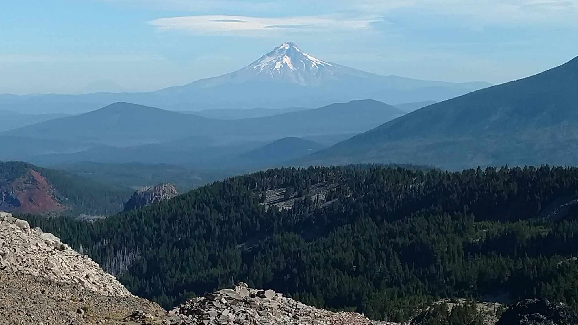
After the road, the trail was officially on Mt Hood now.  It was a five mile uphill climb all the way to the Timberline Lodge.  By my best guess, I should be there by 9 am.  The trail was steeper than normal but not a bad climb, but I did generate alot of sweat.  There were two water sources on the way up, but I had enough water to get there without any more.  I did get hungry on the way up, and had to stop for a Clif bar.

About a mile and a half from the lodge, the trail popped out of the woods and went straight up an arm between two canyons.  The trail here was very soft sand and it was like climbing a giant hill on the beach.  It was a very tough climb and so demoralizing being so close to the lodge.

When I got to the top of the hill, the trail was actually above the Lodge.  It went right around back into a small section of trees that were a designated campsite for the trail, just 300 yards from the lodge.  I am sure none of the guests had any idea they were so close to a small village of homeless hiker trash.

I made my way down to the lodge and set my pack outside one of the back doors and cooled off for a few minutes.  I changed into my town shirt and went inside.  I had to wait about ten minutes to be seated in the dining room.  They like to keep all the hikers together and I sat with two other hikers.

The buffet was everything I had hoped and dreamed for.  Eggs, sausage, ham, potatoes, fruit, granola, yoghurt, waffles, and pancakes.  The coffee was good, but the food was better.  I only had two plates since this is a meal after a hike and not loading up for more hiking.  I was quite hungry by the time I was seated.

Next up was to check on the bus schedule.  I had just missed the last.morning bus and would have to hit the first afternoon bus at 2:45.  I had called Steve about a week back, and he invited me to stay with him, so after figuring out all the connecting busses, I texted him with my estimated arrival time.  It worked out almost perfectly because he works near the airport and would get off work about an hour before the last bus made it to the transit center.

I made all my connections and all the busses were on time, so Steve was right there when I arrived.  It’s been at least five years or so since I had seen Steve when he came to Florida and we went tubing down the Itchitucknee river.  I’ve gotten gray and he looks.exactly the same.

We hit two breweries downtown and had appetizers at both of them.  We got flights and all the beers were good.  One was a raspberry radler and it was quite tasty.  I still can’t believe there are 84 breweries in this town.

We went back to his house and chatted a while, before showering and starting a load of laundry.  Getting clean never gets old.  Tomorrow I will do my chores in town and fly out of Portland before dawn the day after.  So this is the last blog entry for the next nine days.  You’ll have to go back to reading about the Trump/Clinton election for your entertainment for a while.  Enjoy that.
PCT mm 2088.4 – Mt Hood in your face

image

Another long day today trying to get within striking distance of the Timberline Lodge for the breakfast buffet.  I should have stopped early and rested up, but the thought of having to eat lunch instead of a buffet breakfast just wasn’t sitting well with me, so I hiked close to an hour in the dark to be within 6 miles for a quick morning jaunt to Nirvana.

I had a really good camping spot last night.  All of the other spots that were right after where I stopped were not nearly as good.  I was out at 6:20 and inspected each tentsite I encountered and was glad I stopped where I did.

The entire day was in heavily wooded forest that was very shady and cool.  Even in the few open areas I encountered where the sun was very hot, a breeze was around most of the day to cool things off.  Even though there were several big climbs throughout the day, they seemed to just whisp by quickly.  Perhaps the coffee I made at 8 am to ensure that I did not drag my feet had something to do with it.

A very large lake was the prominent feature for the day.  The trail went half way around it for several miles with a nicely shared and nicely flag trail.  The far end had ice cold springs pouring into it so I filled up and made another batch of coffee to see how close I could get to the Timberline.  That batch helped, too.

The other prominent feature was a horse camp near the lake and I saw three couples riding horses on the trail.  On the entire previous 2000 miles, I only saw one other couple riding horses (with a mule in tow).  The trail was covered in road apples all the way around the lake and many trails leading into or away from it.  Popular place.

At about 6 PM the trail popped out on a ridge and Mt Hood came into view for the first time all day.  We were close enough now that I could actually make out the lodge.  I was twelve miles away via trail, and probably less than eight as the crow flies.  I also got good cell signal for the first time since leaving Bend.

There was flat terrain three to four miles ahead, which would put me eight to nine miles from the lodge.  That would have me at the lodge at about 11 am if I left at 6 am.  When I got to the flat area, it was pretty heavily forested with lots of dead trees.  The camping was not good, and I was feeling good, so despite it being 8 PM and almost dark, I decided to go to the next pass and trailhead which was only six miles from the lodge.  I was well fueled and hiking quickly.  There was a bit of climbing, but it whisped by quickly.  As I was getting near to the road crossing and pass, the number of tents in the woods increased.  I was not the only one trying to get there for breakfast.  I found a level spot on the ridge and cleared the twigs and set up camp just after 9 PM.  I am now seven miles away.  The next mile is a descent, but the last six are all climbing, so it will still take at least three to three and a half hours in the morning.  I’m pretty sure coffee will be required.  An alarm might be required, too.  Breakfast is served from 7:30 to 10:30 so I should have enough time to make it.

The whole reason for all this fuss about breakfast is that the lodge is very fancy and very expensive.  But their breakfast is a buffet and only $15, which might sound like alot, but it’s cheaper than lunch and their breakfast is supposed to be the best on the entire trail.  I wouldn’t want to miss out on that, would I?

PCT mm 2055.5 – Mt Hood enters view

image

A long day today that started out much tougher than I was expecting.  I usually have twelve to fourteen miles in by noon, but I only had barely over ten today.  The morning was spent climbing over a pass to enter into the Mt Hood wilderness.  And right at the boundary was the first real view of Hood.

I got up about the normal time and listened to music a little longer than normal and the bagels this morning were everything bagels and not presliced so I had to get up and out of the tent to eat breakfast.  I think I was on the trail about 6:30.

The morning was very cool and breezy.  And since the trail was on the west side of Mt Jefferson, it was also very shady with no direct sun.  Jefferson is a pretty big mountain with lots of snow still on it, so the two streams we had to cross were not trivial, since they were full of raging snowmelt.  Pat had said to try to cross them in the morning when there was less snowmelt, but I don’t think it helped.  I didn’t get wet on either one, but I did have to go upstream sixty yards or so to find rocks I was comfortable crossing on.

Later in the morning, the trail split off of Mt Jefferson and kept climbing to the next butte to get over a pass to get to the Mt Hood wilderness area.  It was probably 10 am when I hit the pass and the view was incredible.  You could see Mt Hood immediately to the north, Adams to the left of it, and St Helens further left.  These volcano mountains stick out like a sore thumb among the others.

The trail down the pass was steep and rocky and passed a large snow field.  There were multiple trails down and it was easy to avoid the snow, but it was hard figuring out which was the real trail.  The trail finally got back down to the woods and got a bit easier again.  It also started passing many lakes, large and small.

I stopped for lunch a little early the side of a lake because I needed to stop for water.  There were several other hikers there eating as well.  More hikers came as some left so there was always a small number of hikers there the whole time I was there. 

It was six miles to Lake Ollalie Resort where I planned to stop and have a coke.  I didn’t need any food, but coke is like crack cocaine to a hiker.  Those six miles took forever.  I have no idea why, but I was slow as molasses all morning and afternoon.

I finally made it to the resort store, which was a quick five minute walk off the trail.  They had no power in the store, but had a refrigerator and freezer that I am guessing ran off of propane.  They had a small solar panel to run credit cards.  I got two cokes and a snickers.  Those went down quickly, so I had to add a Pepsi and a whole tube of Pringles.  And why not get a Klondike bar as I leave?  My coke stop got quite substantial, but it did the job because I was hiking much faster all afternoon and into the early evening.

When I finally stopped for water, it was seven and several other hikers had also stopped.  I was planning to go until about eight, but the terrain afforded no campsites so I had to go until about 8:45 before I found a good campsite.  Walking thirty minutes in the dark is not that big deal, and did put me close to 28 for the day despite a slow start.

The Timberline is now 39 miles away, which probably puts it a tiny bit too far to get to for breakfast on Monday.  I’ll see if I can do more than 30 tomorrow to put me less than eight for Monday morning.  The next two mornings I need to get early starts to be able to have a chance.  I might need to start cutting music time a little shorter.  These are the sacrifices I have to make to make the miles.

PCT mm 2027.8 – Back into the mountains

image

I was able to make some good miles after an early start and moderate terrain.  The morning was mostly burn area, but the scenery was entertaining and kept getting better as the day wore on.  Most of the late afternoon and early evening was heavily forested.

Pat got up before 5 am so he could get me out on the trail before he had to go to work.  Molly was ready to play as usual, but we got ready and got rolling before 5:30 and I was out on the trail at my usual time at 6:20.  I saw several people within the first mile which surprised me.  In fact I saw probably two dozen people throughout the day.  It is the beginning of the weekend, after all.

The morning was all burn area.  Pat said that it burned the day George Bush showed up to town, so everyone blames the fire on George Bush.  Hilarious.  Three Fingered Jack was the first mountain to climb.  The top is very rocky and crumbly, but the PCT only went about half way up.  There were a few spots with trees and I found a good one with excellent rocks for sitting, so I stopped for first lunch there.

The next several hours were also burn area, but the scenery kept getting better as Mt Jefferson came into view and we also went around the side of it about half way up it.  The ponds in this area began to get bigger and a few snowmelt streams began to show up, too.

On my break for lunch number two, I ran across three brothers and their brother-in-law out for a weekend jaunt.  They were very nice and one of them I told him that he looked like Tim Tebow.  They laughed and then the conversation turned to football.  I saw them again at the next lake where they were all swimming and one of them invited me to camp with them.  I enjoyed talking to them so much that I would have, but I needed to do ten more miles since I’m on a time table now to get to Portland in time to fly back for the wedding in Pennsylvania.  They looked like they had fun when they got together.

I kept hiking until nearly 8 PM and found a decent campsite near a stream that had lots of blowdowns to sit on for cooking.  There are a few mosquitoes but not enough to make it annoying.  I cooked a black bean and corn dish, ate my usual tuna packet, had a few nuts, then mango cookies for dessert.  The feet were getting sore the last hour, but my left ankle was bugging me since about noon.  Taking time off always brings new pains.  I hope tomorrow goes as smoothly as today.

PCT mm 1998.6 again – Zero in Bend

image

I had a nice easy day today going into town to buy food for the last four days of this part of the trip.  Relaxing and resting was the name of the game today.

I’m not sure what time I got up today, but it was well after six.  I watched news with Pat for a short bit and he made us coffee.  I have really enjoyed not hearing what is going on in the election circus.  Pat headed off to work and I went to work on the gear.  I got my laundry going and then watched some news with Kelly.  More news than I’ve watched in three months.  After getting the laundry into the dryer, Kelly let me borrow her truck to go into Bend for grocery shopping.

Bend has grown since the last time I was here, but everything is still recognizable.  First stop was a bakery to grab a cinnamon roll.  I got an apple walnut raisin one and it was excellent.  Next was Trader Joe’s.  They have so much interesting stuff there that it’s hard to get out of there without buying too much.  I got most of what I needed there, but still needed lunches and tuna.  Food For Less was next door and I was able to get everything else right there.  I still had some time, so I decided to look up a brewery that a hiker had told me to visit in Bend, the Goodlife brewery.

I found the brewery after a little searching and had to search more for the tasting room.  I ordered a flight and they were all pretty good.  They had food, but I didn’t feel like eating there, so I left.  But right outside was a food truck with BBQ.  I got a pulled pork sammich and it was pretty decent.

I headed back and Pat was already home.  We chatted as I packed the food bags and we had to sample all the interesting dried fruits I had gotten at Trader Joes.  We tried the coconut cashews, dried mandarins, and freeze dried mangoes.  The fruits were good, but the nuts were just OK.  Everything was packed and ready to go.

One of Pat’s neighbors came over to chat about the PCT.  He had lots of questions and it was fun answering them.  With all the visitations done, it was time to get down to business.  One of Pat’s climbing buddies had opened a brewery and Pat had done the heating and chilling work for them, and they named one of their beers after him – Pat Kat Porter.

So we headed down to the Juniper Brewery to have some Pat Kat Porter.  They had flights of 4, 7, or 12 beers, so I got the 7 and made sure to get some Pat Kat.  It was pretty dark and closer to a stout than a porter, but it was good.  The others were good as well.  We went back into the brewery area and saw all of Pat’s handiwork.  They were a 2 barrel operation, which is quite small, but better to start out too small than too big.  Brewery equipment is not cheap.

We headed to a burger joint for a quick bite then back home.  We had an early wake up to get to the trail by dawn, so it was just brief chit chat before heading to bed.  In the picture, Pat is holding his boot from his Appalachian Trail hike that his mother had bronzed.  He and I both have nearly all the equipment we hiked with in the eighties, but I don’t have any footwear from that period other than one pair of boots identical to the ones I used back then, but will probably never use again.

I’m glad I was able to get Pat’s number and was able to get ahold of him.  It was a really great visit and it was nice catching up on what each of us has been doing for the half of out lives that we have missed.  He has been out here doing all the skiing and rock climbing that I expected that he would be doing out here.  All things that I would have loved to do as well.

PCT mm 1998.6 – Bend, Oregon

image

Had a nice cool morning walk without too much moon rock, but it was through a very large burn area.  My friend, Pat, from Jacksonville, took off work early to come all the way out to Santiam pass to pick me up and we had a nice lunch at a brewery in Sisters, then he took me back to his place and we had dinner with his girlfriend.  It’s been a very good day.

This morning was not as cold as yesterday, despite being at a higher elevation.  I slept in a little, but still managed to get out at 6:30.  There was some more lava rock to walk, but my spirits were higher and my feet a little more refreshed.  I saw only four hikers all morning, and about eighty percent of the forest was burn area.  The few areas that were not burned just pointed out how fantastic the forest used to be here.  Fire ruins an area for decades.

I was eager to get a cell signal to be able to text Pat and let him know my ETA at Santiam pass.  I had told him yesterday that I thought it would be around 2 PM.  But the morning was going so smoothly that it looked like it would be closer to noon.  All of the cell towers were to the east, but the trail was on the west side of the mountains so all morning I had bupkiss for signal.  Finally, about three or four miles from the pass,  I was able to get a signal and text him that I thought it would be closer to 1 PM.  I knew it would be a while before I could get something to eat, so I wanted to have an extra hour to cook lunch.

Lunch took about 45 minutes and allowed my feet some time to recover from the lava.  Ramen noodles and dried fruit taste pretty good when you are hungry.  I was running low on water and it was starting to get warm, but I still had enough to last the rest of the day so I skipped loading up at the lake just before the highway.

I got to the highway just before 1 PM and it was a very busy highway.  There was no shoulder for cars to stop to pick you up.  Another hiker arrived just after I did and found a sign someone had left for hitchhiking.  That’s Boy Scout you see in the picture hitching into Sisters.  It took him close to an hour to get a ride, but he did get one.

I noticed there was a trailhead turnoff just down the road and the trail intersected with he trailhead just 0.2 miles ahead.  I texted Pat to let him know that was a good place to park and that’s where I would be.  Pat showed up just after two and he had not changed a bit.  I recognized him immediately.

He took me to Sisters and we stopped at the local brewery for a bite to eat.  I had a calzone and a flight of beer and it was great.  Sisters itself was a bit touristy, so I’m glad I didn’t end up staying there.

Pat took me back to his place and showed me around.  It was amazing to see the trees change from ponderosa to juniper in just a very short distance.  I got to meet his girlfriend,.Kelly,.and their dog, Mable.  Mable is just nine months old and full of energy.  She’s a really cool dog and incredibly smart for such a young puppy.

Kelly had made dinner of chicken pot pie which was fantastic.  We had a couple of beers and talked about the old days around the neighborhood and of the Appalachian Trail and Pacific Crest Trail.  Pat had completed the AT in 1984 and gave me alot of pointers back in 1989 when I first hiked the trail.  He had hiked the PCT a few years later, but when he got to Bend, he bought a mountain bike and rode to San Francisco.  I had always thought that he was going south to north, but he was going north to south.  So collectively, the two of us together had hiked the PCT already.  Too bad I can’t just stop now.  Nah, I’m ready to finish this thing.  I’m just a mile and a half from 2000 miles, and then it’s just another 650 to Canada.  Yep, I’m ready to finish this thing.

PCT mm 1984.1 – Mars returns

image

A very long day today.  Both in terms of miles and the difficulty of those miles.  Of the 29 miles today, probably close to 10 of those were on lava fields.  And for the record, lava fields will obliterate your feet.  My feet would have felt better today if not for the lava.

I woke up at 5:20, but I must have listened to music for too long or took to long with breakfast or something, because I did not hit the trail until 6:20.  Last night started out very cold, but this morning did not seem as cold as yesterday morning for some reason.  Once I got walking the cold came on with a vengeance, though.  As I got down to the lake I was trying to get to last night, it got noticeably colder and everything was covered in a thick frost.  I even passed a group of six or seven hikers all cowboy camping on the same tarp and all of them were covered in frost as well as all of their gear.  Looks like stopping a few tenths up the hill paid off handsomely for me.  I saw frost in the shadows well after 9:30.

The morning stayed cool even out in the large meadows with the sun shining down on me.  I held my hands out to the sun to try to warm them, but it did not work.  The wind erased anything that the sun managed to do in the warmth department.  The views of South Sister mountain were fantastic all morning.  I had seen pictures of this meadow before and always thought it was lush grass.  It turns out it’s dead gravel with just enough green weeds to give the illusion of grass when viewed at a shallow angle.

I managed to get to Obsidian falls for lunch.  I rolled everything out right in front of the falls and cooked away.  It was a nice break and the spring that fed the falls was the coldest spring of the trip by far.  There were multiple springlets all pouring out frigid water headed for the waterfall.  Too bad it had a high iron content, or it would have been the best water on the trail.

Shortly after lunch, the first of the lava fields started.  The first one wasn’t too bad.  It’s treadway was mostly sand and tiny gravel.  It was easy on the feet, but it was a big climb, so it went slowly.  The views were incredible, though.  From the valley, the flows look like eighty foot high piles of rocks.  But from the top of the mountain where they originated, they look like rivers of rock flowing away from the mountain.  Fun to look at, but not fun to walk on.

I still had several miles to go to McKenzie pass and it was near 4 pm and I was tiring, so I made some coffee.  It always does the trick.  Shortly after 4:30, I got a text from Ireland that they were in their hotel.  Good for them, I still had five miles just to get where they went into town from.

The trail was nice, but a mile out from the pass, the lava returned and it was just the perfect size to not be able to walk on it.  That was the longest mile of the day.  It took a while, but I finally made it out to the pass at 6:30.  I was beat and hungry.  There was a van there and several hikers.  It took me a while to figure out what was going on, but it looked like the father of one of the girls was following her down the trail.  Another girl was going to ride into Bend with them.  They offered me a ride, but I still thought it would be better to hit town from the next pass earlier in the day where I could actually get chores done and not have to stay another day.  I graciously declined.  I have better luck with rides when I am NOT looking for them.  Santiam pass better not be a nightmare hitch.

Two of the other hikers that were there were a mother and son duo and the son couldn’t have been more than ten or eleven.  I know the record is something like seven for the youngest through hiker, but this kid seemed so young to be out here this long.  He seemed to be enjoying it, though.  He had an adult pack that looked absolutely huge on him.

The trail North of the pass was just as bad as South of it.  It was five miles to the next campsite and it looked like at least four would be nasty rocks and a 1000 ft climb to boot.  It was already after 7 PM so this would be a headlight finish to a long day.

The climb up was not bad, but the rocks were.  It seemed every minute I would hit my foot wrong and have shooting pains.  Luckily, it was only three miles of rocks, so I was able to find a campsite high up, but it’s soft and flat and I got there at about 8:20 so I was able to set up camp and start cooking in the waning light.  Wearing flip flops at night always helps and my feet already feel better.  I’m hoping I can find a reasonable place to stay tomorrow to rest up a bit.  I’m looking forward to it.

PCT mm 1955.7 – A calm cool morning

image

When I awoke this morning, the temperature was significantly colder than it has been since the Sierras.  There was a small amount of dew on everything and I did not want to get out of my warm sleeping bag.  But I did get up at six and was on the trail at 6:30 without the extra insoles today.  The day was full of lakes again, and towards the end of the day, I am starting to get within sight of the big ski mountains, so Oregon is getting ready to change again.

The morning stayed brisk well after 11 am.  For the first hour or two, I wished I had my gloves.  I walked a while with my hands under my armpits, and walked much of the time with my thumbs tucked under my fingers.  Believe it or not, that will warm up your hands.  It was so cool, I probably walked thirteen miles to lunch on just over one liter of water.

I found a nice pond with plenty of shade for lunch.  I made ramen noodles and ate a little bit of cheese.  I took my shoes and socks off and trimmed toenails and fingernails.  The feet didn’t look too bad, other than being dirty and the skin tough as nails.  The heels are still sore, but the toes are much better today.

After a long lunch, it was time to get going again.  The afternoon was more lakes.  There was a brief hot stretch, but it was mild in comparison to previous days.  I actually laid down on a sunny rock at one point to dry the back of my shirt off during one climb.  It was such a cool day, the sun actually felt good.

Along one stretch of trail, I finally came upon some travellers on horseback.  I don’t know where they started, but they were only going to Odell lake where I was the night before.  It was a man and woman on horses pulling a mule with all the goods on him.  It was a very brief chat as they sauntered by me after I got about eight feet off the trail.  The mule was almost solid white.  I don’t think I’ve seen a white mule before.  The rest of the day I inspected all the road apples I saw so I could get better at estimating the age of road apples when I see them the next time.

Late in the day, the trail final climbed a bit and popped out of the woods.  After not seeing anything but forest and lakes for the last few days, it was a change to be able to see big mountains again.  Mt Bachelor was to my right and the South Sister to my left.  They both looked pretty big.  I go around South Sister tomorrow, but don’t get any closer to Bachelor.  The lake just to the right of it has a resort on it that Karen and I visited in 2009 and we both remember being shocked at having to pay $3 for a coke.  Now I see prices like that all the time.  It was not worth the one mile side trip just to get something to eat.  Elk lake resort is not on the itinerary this year.

I kept going up the big climb and was surprised to find good signal most of the way up.  I was finally able to look up the number of a friend that used to live in Jacksonville just down the road from where I grew up, but now lives in Bend.  This same person also hiked the AT and PCT in the 80’s and was the one who mentored me before my first hike on the AT.  I was able to get ahold of him and we are planning on having drinks or dinner probably Wednesday evening.  There are two ways to get to Bend from the trail and the one I hit tomorrow will be too late in the day to be able to do anything.  So I will probably hike on to the second highway if I can hit that earlier in the day to be able to hitch into Sisters and/or Bend.  I’m still not sure where I am staying yet, the hotels in Bend are $250 a night.  Sisters is a bit more affordable at $80 a night.

I also heard from Ireland via text.  They are camping about five miles past where I am camped and will be hitting the first pass at 4 PM tomorrow and staying in Bend two nights.  I don’t think I can hit that pass by 4 PM, so I doubt I will ever see them again unless I can hook up with them in Bend.  The next two days will be interesting.

PCT mm 1927.4 – Land of lakes

image

The terrain is starting to change again.  More and more large lakes are starting to show up and they are starting to become the primary source of water.  After leaving Odell lake where the resort was, I must have passed nearly a dozen lakes and the third shelter of the trip so far.  I saw about eight southbounders and over a dozen weekend hikers today.

Since it took so long to get laundry done last night, I slept in until about 6:30.  That would give me enough time to pack up before the store opened.  I packed everything up, drank my Izze grapefruit soda and took my garbage and one water bottle with me to the store.

The store didn’t have anything special for breakfast,.so I got a hot pocket from the cooler and a fresh coffee.  The hot pocket was about what you’d expect, but the coffee was quite good.  She made it from a fresh espresso and water.  I must be getting close to Seattle.

I talked with a southbounder for over half an hour about what he can expect and he did the same for me.  I filled up my water bottle and made my way back to the campsite.  Gator and Nuthin were just waking so I said goodbye to them and headed out.  The first mile plus was a road walk and then about three quarters of a mile to get back up to the ridge where the PCT was.  It was about 9:15 before I got back on the official PCT.  A bit later start than I was hoping for.

The morning was cool and the trail was lush pines.  The trail circled around the north side of lake Odell as it climbed up the ridge.  It eventually crossed a highway and kept climbing on the other side.  Most of the morning was gentle climbing as it passed three Rosary lakes.  I noticed there was a shelter that I should hit about 12:30 so that seemed like the perfect target for lunch.

I hit the shelter a little early.  It was only 150 yards off the trail and it’s a pretty unique one.  It’s an octagon with a vestibule and a big second floor loft for sleeping.  It had lots of tables and chairs inside and was very clean.  It was the perfect lunch stop to have my salad and cookie.

As I was finishing my salad, a southbounder came in.  We had a similar exchange of information that I had earlier in the morning.  I offered her one of the three plums I had packed out.  She was very grateful and offered to pack out my salad trash.  I gave her the last plum as a reward.  It’s not often someone offers to take your garbage.  She had three hours to a garbage can but I had three days, and the salad bowl was awkward to pack.

I checked the afternoon maps to see where was a likely stopping point.  24 miles from the start of the PCT from this morning was a lake named Irish lake.  It sounded like the most likely place Ireland and Shiloh would stop for the night.  I would try to make it, too.

The afternoon had a mix of ups and downs that were graded well and I passed several more large lakes.  I was running low on water so I stopped at one to fill up.  By 5 PM I still had nine miles to go, so it would be questionable if I would make Irish lake or not.  My feet were killing me, so I was starting to slow.  I had made coffee at 3 PM when I filled up with water so I had energy, but the feet were howling. 

I tried something odd today.  Since my feet were hurting yesterday, I decided to try to find some insoles in the hiker box to put in my shoes.  I found some used ones, so I had put them in my shoes in addition to the ones already in my shoes.  They were starting to rub my toes raw since they were molded to someone else’s feet that were slightly smaller than mine.  I think I made things worse.

The last hour of the day was a burn area and it was a thoroughly burned one.  But new trees were beginning to grow to replace all the dead trees.  As soon as it turned to woods again, there was lots of flat ground to camp.  I was less than a mile from Irish lake, but it was already 8:15 and my feet were done.  I stopped, set up the tent, took my shoes off, then made dinner.  Ireland and Shiloh will have to wait another day for me to catch up to them.

PCT mm 1904.1 – Shelter Cove resort

image

A long day but a good day today.  And don’t look at the mileage, I did not do 35 miles today, it was actually 27, but I was done by 6 PM.  There was an alternate trail today that was the old PCT that a group of us took because it had more water than the PCT and was 8 miles shorter which meant we could get to shelter cove resort tonight instead of tomorrow afternoon.

The group I was with last night are all earlier risers than me, so I was the last one out of camp.  Since I had only one and a half liters of water to go eight miles, I was checking every road crossing to see if there was a cache just as backup.  At a road crossing six or so miles into the morning, I see register entries about an empty cache.  Darn.  But I also see entries about water down the road to the right and there also being an alternate trail that used to be the original PCT and that it was flat, had lots of water, and eight miles shorter. 

Hmmm, the prospect of getting to resupply a day early definitely had my attention.  The next water on the alternate was three miles further than the PCT, and I had half a liter left.  That was just the right amount to go another hour, so I decided to take the alternate.

As soon as I got to the intersection, I saw an arrow pointing down the alternate.  It must be a recommended alternate.  As I hiked down it I saw tons of fresh footprints, so it must be a popular one.  As I approached the water, I found the group of four hikers I was hiking with yesterday resting on the side of the trail.  Perfect.  They had seen the register entries as well and also noticed it was marked on the Halfmile maps.  I had noticed that the Halfmile app knew the trail and had all the trail junction and water waypoints.  Double perfect.

So the five of us trucked on down the trail together, Ireland and Shiloh in the lead, with Gator and Nuthin shortly after, and me slowly getting further and further back.  When they stopped, I stopped, when they ate, I ate.  The trail was extremely dusty, so I preferred to be pretty far behind them.  But even if I wanted to, their pace was just a tiny bit too fast for me.  And my left foot was getting sore and possibly getting a blister, so I didn’t want to push too hard.  It was a very nice combination of hiking with others, yet hiking alone.  I will probably see them quite a bit over the next week, but won’t see them again after I have to head to Portland to head home for the wedding.  They will all finish a week ahead of me.

I hit the store at about a quarter after six and the store closed at 7 PM, so I had to make my choices quick.  I needed two days of food, but Shiloh and Gator had extra food in their resupply boxes, so I decided to wait until morning to shop for resupply and only focused on dinner.  I bought a hot dog, hamburger, salad, two sodas, a cookie, and a half gallon of ice cream.  Sounds like alot, right? I saved the salad and sodas and cookie for breakfast, but ate the others.  And while sitting there, campers brought us London broil tacos, a box of apples, and a box of pears.  I had one of each.  (Late update: a bag of small plums showed up, so I ate two and grabbed five for breakfast)

Shiloh and Gator opened their boxes and between the two, I have two days of food, so I actually don’t need to buy anything from the store in the morning.  I have enough food, so I’ll probably sleep in a little bit, and if I’m still here at 7 am when the store opens I’ll probably buy a pastry and a milk and head out, otherwise I’ll probably just head up the trail.  I may be able to catch up to the others tomorrow night, or it might take me two days, but I’m pretty sure I will catch them before the next town.  They are very predictable.  They hike 25 miles, then camp.  Doesn’t matter if they get there at 3 PM or 11 PM.  When they hit 25, they stop.  I have been doing closer to 28, so I should be within six miles of them when I set out.

They have showers and laundry here, so I decided to pay the $10 to camp and take advantage of the facilities.  The shower was $1.50 for three minutes, so the feet did not get sparkling clean, but I can see them again, so that is nice.  When I went to do laundry, I forgot my soap, so I had to go back to camp, about 20 min walk.  When I got back to laundry again, I put my coins in the dryer slot, not the washer slot, and I was fifty cents short for both, so I had to go back to camp again to bum fifty cents off another hiker, so it took 45 minutes just to start my laundry, and now it’s another 43 minutes for the wash.  Who knows how long I will have to wait for the dry.  (Late update: 45 minutes)  I may not get to bed until after 11 PM tonight, so know knows how long I will sleep in tomorrow.  As I write this now from the porch of the store, the wash is about to finish.  I hope the rest of the evening goes smoothly.