Page 17 of 32

Day 1 mile 4.5

What? Only four and a half miles?  Yes, but what is not told in the story is the eight mile approach trail.  I’m not counting the number of this trip yet, but there are always numbers to count.  I am purposely trying to limit my miles the first three days to 13 to 15 just to make sure I don’t overdo it too early in the trip and injure myself.

The day started at the hotel with a leisurely wakeup, a quick shower, and a brown bag breakfast since the hotels don’t want to deal with a buffet line during covid.  Suits me just fine.

I got on the road and hit a Starbucks since the hotel coffee was horrible.  Driving through the mountains was nice.  We ended up getting to Amicalola Falls about 10, hit the bathrooms, then sent Karen on her way about 10:30 and I was off.

The first excitement of the day started before I even made it out of the lodge parking lot.  I walked under a zipline and watched the people zoom overhead.  It looks fun.  I’ve never done it but would like to try it some day.

Since I started at the falls, I did not go through the arch at which you see everyone taking their picture.  I don’t even remember there being an arch thirty years ago.

At the top of the falls there were quite a few people milling about taking pictures.  I squeezed in and took a quick one and was on my way.

The morning was quite pleasant.  The temperature was not hot and a gentle breeze now and again kept me cool, but the uphill nature of the trail kept me sweaty most of the day.

I decided to try some cold soaking of ramen noodles for lunch.  I added dried shitake mushrooms and TVP and it dually improved it.  Twenty minutes is all it took.  I stopped to soak them then kept hiking and stopped again later on Frosty Mountain to eat them.  I will definitely be doing that more.

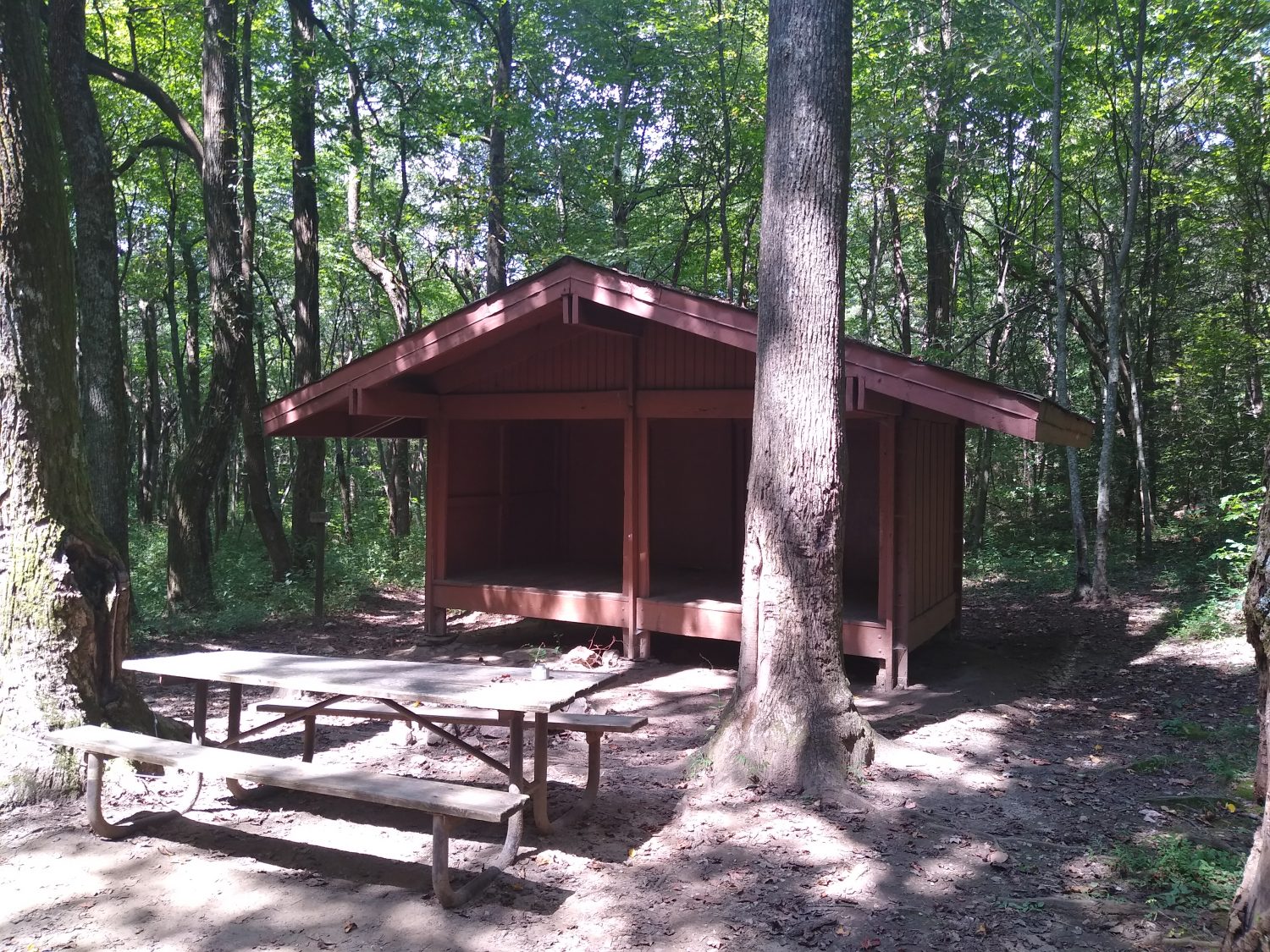
Later in the afternoon it got a little bigger but I took a break at the “new to me” Black Mountain shelter.  It looked just like the one I remembered being at the top of Springer.  After reading a bit, I found out it was the same shelter.  At some point they removed it from Springer in a disassembled state and reassembled it at the new site.  They also painted it a darker brown.  It is in a good location in it’s new home.

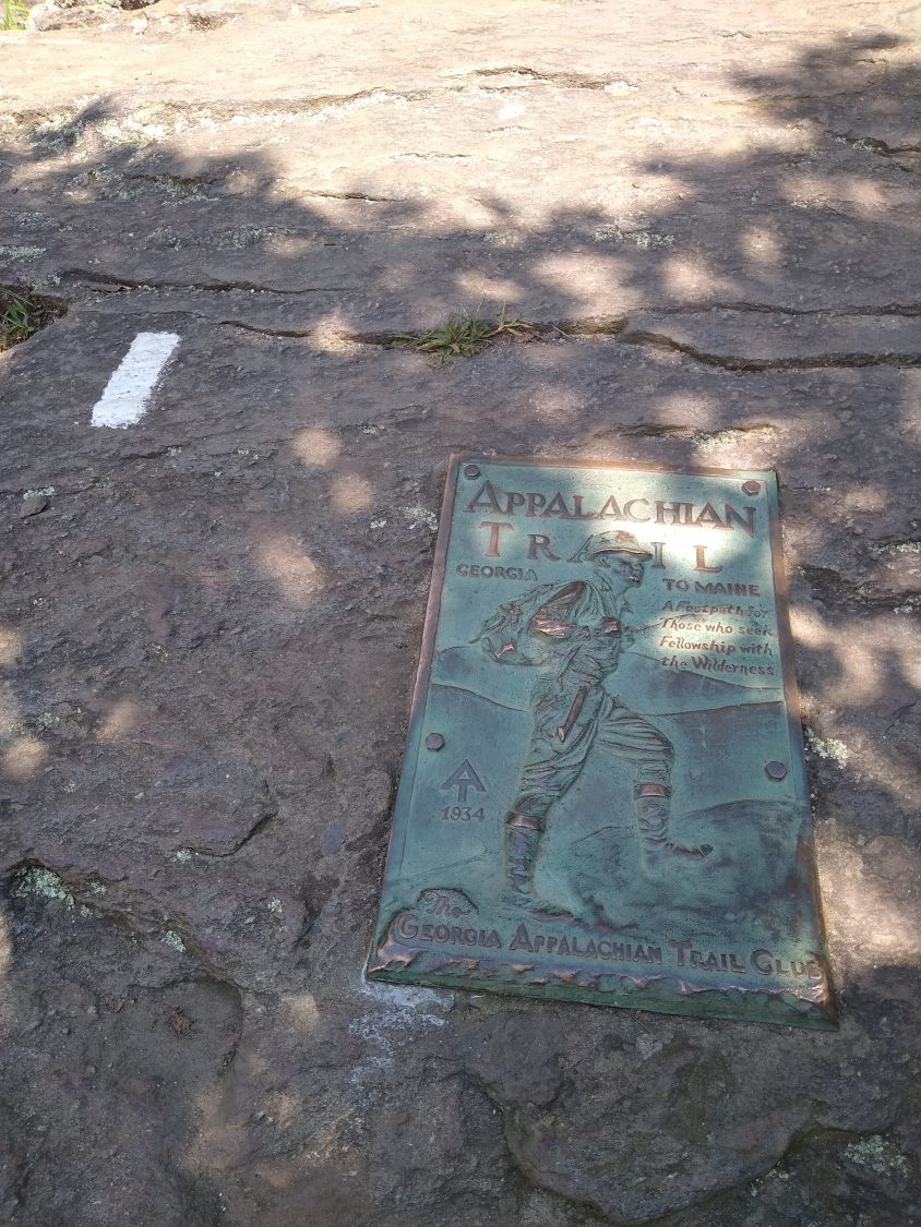
When I got to the top of Springer, it was not as I remembered it.  It seemed smaller, more closed in, and more forested.  The trees have grown for sure, but the rock itself looks the same.  I took a quick picture, talked to a previous thru hiker from 1992 and headed on.

I took the side trail into the new shelter down from the peak and it was a nice two story shelter that looked like it could sleep at least twenty.  One person was camped nearby and a couple I met on the trail had just arrived and were about to set up camp there.

I moved on and made it to the parking lot at the forest road and it had been expanded way larger than I remembered.  I remember it being large enough for only six or seven cars, but now it could hold at least thirty plus lots of parking along the road.  There was a guy all spread out there looking for a lighter.  He spooked me so I told him I did not have one and moved on.

From this point onward, the trail should be more sparse.  I was seeing a hiker every five to ten minutes up until this point.  Three Forks is where intended to head and there is road access there, but I don’t expect to see many hikers, just campers there.  My guess was right, as there were three large groups there at the forks.  Just a quarter mile downtrail, I could not hear the screaming kids, so that’s where I stopped for the night.  It was about six thirty, so I made camp quickly, got dinner cooking, and washed with the ample water from the stream.

One other unsuspected thing was finding out that Stover Creek shelter is no more but has been replaced by a nicer and bigger one.  I met another hammock hiker there who was fixing dinner, so I chatted a bit and had some water then moved on.

All in all it was a good first day and I am glad that nothing went wrong and the weather was good.  If I can keep a slow and steady pace for a few more days, then I should be ready to start pouring on the speed if my body will let me.  It is neat that I am camped at essentially the same exact spot I camped at thirty one years ago.  On almost the same day of the month too.  It is now September 6th versus May seventh.  It will be neat to compare how far I went each day back then with this trip.  I have a feeling this one is going to go much faster.  I am older, but also more experienced and have a much lighter pack and much better shoes.  It is going to be an interesting comparison.

Travel Day 0

The first day is never the first day. The first day is normally the day before. So today is finishing up work, finishing up packing, and driving to Atlanta.

The morning started with trying to get the WordPress app hooked up to the site. I have been fighting with that for two years now. Instead of fighting it any more, I’ll just have to start posting online. I will probably do the content creation in gmail, then transfer when I have signal. We will see how much of a pain that becomes. I wish I had someone I could assign admin rites to back home who has a full computer for editing and fixing things. Any takers?

I am only sending three boxes, so packing up boxes did not take too long. We packaged the various dried goods into individual ziplocks and filled the boxes. The one to Fontana is stuffed to the gills. The others less so. I am probably packing too much into each box, but then that is usually my classic mistake on each hike.

I had a few more things to take care of around the house so we got a late start, but traffic was not bad and we got to the hotel exactly when we had planned to arrive. A quick stop at the local brewery to pick up some beer, then the pizza parlor for a pie and it’s time to hold up in the hotel.

Now the long wait for morning to arrive….

Time for a new trip… to an old home… the Appalachian Trail

As fate would have it, I have the opportunity To be able to take a break from a stressful job and take a seven week sabbatical to go hike in the woods again. The timing is both good and bad. On the work front, most projects are complete or well on their way to completion. September is a good month to hike at higher elevations, out west, or up north, but not that great in Georgia. But I have decided to go back to Springer Mountain again and begin there and head northward.

The primary goal of this hike is to regain The fitness that has dwindled away after being stuck behind a desk for so long now. It will afford a mental break from technology, too, and cannot come soon enough after dealing with burnout for the better part of a year.

so I will start at Springer Mountain and head north. How far north? As far as I can get. My normal pace says I should be able to get to Shenandoah National Park, but only 100 miles further is Harpers Ferry. I will start out slow, try not to worry about the daylight shrinking quickly each day, and just make steady progress northward.

2020 is the year of the Covid-19 virus outbreak, and probably not the best year to hike, but I don’t have much choice. The trail is not closed, all agencies have the trail and trailheads open, most services along the trail are still open, and most importantly… the Smoky Mountain National Park is still issuing thru hiker permits. I have mine in hand and will see how the park has changed in the last thirty years since I have been there. The only adjustments I have made for Covid are not registering for a start date (they are not issuing them), bringing a larger bottle of hand sanitizer, and bringing a face mask for towns. I will not be staying in shelters and probably no hostels because I am bringing the hammock on this trip and can camp pretty much anywhere. My interactions in town will be limited to food, laundry, and showers, with very few overnight stays.

The gear I am bringing on this trip is pretty similar to past trips, but I am going a bit lighter this time. I am bringing a 35 liter pack instead of 62L which is one pound lighter, bringing a 30 degree down bag instead of 10 degree down or 40 degree synthetic, not bringing a water filter, and not bringing a full stove but will have my tiny alcohol stove. Fully loaded with 4 days of food but no water, the pack weighs 23 lbs instead of 30 or so, so I am digging that.

Updates to PCT 2016 pages

I have not had as much time to work on enhancing and organizing the pages as I would have liked.  Sections through #6 in Central California are up and I am currently working on Section 7.

It takes a lot of work to do these updates, but it has been greatly rewarding to go back and pick through more pictures and relive each day.  It makes me want to drop everything and head back out there tomorrow.


Enjoy the show….

Moving the blog and updating the travel logs

I have registered a domain and have decided to host the site privately.  The free version of WordPress is great, but they do restrict what plugins you can install, and I want the freedom to be able to do whatever tweaks that I want.

It’s been over a year since returning from the PCT, and I also think it’s about time to look through my blog and clean up the posting mistakes that were made from the trail.  I was using the WordPress publishing app on my phone, and an update a few weeks into the trip introduced a bug that made it impossible to edit posts that contained pictures without destroying them.  After a few posts were mangled and I was unable to edit them from the phone, I began posting only one picture, and I now have the opportunity to remedy that problem.

I took over 2000 photos on that trip, and I don’t intend to post all of them (but have them on a Google Album for those inclined to pain) but most days had more than one interesting thing happen.  Being able to go through the daily photos again and post additional relevant photos is a great way to stroll down memory lane.  It also gives me the chance to add an after-the-fact perspective on some things that happened, but might have ended up being quite different in the long run.

The original site was created all as posts (blog), but I am adding a lot of organization with pages to give it a logical structure.  The three main groups of pages are moving info to a FAQ section, and creating AT and PCT page groups.  They are organized from the menu on the left and also have links within the pages.

It takes me at least an hour per daily page, so this has been slow going.  As I finish updating a blog entry, I am adding the text “Blog:” in front of the links to identify which ones have been polished.  If you are following this in the fall of 2017, you are welcome to read anything that is not polished yet, but the polished versions are greatly expanded, so you might do to wait a bit to let me get ahead.  You can subscribe to updates or the RSS feed to be notified when changes are ready.  I will probably also post a blog page when a new major section is complete.

I wanted to thank all the friends and family who followed along, both on the AT and PCT hikes and posted comments.  I did not respond to all of them, but I did indeed read all of them.  All of the comments were moved over from the original site so they are still preserved here.

Enjoy the blog (again).

PCT – On the way home

The last day was bittersweet.  I had camped just 3 miles from the trailhead, did a little backwoods sighseeing, then it’s off to play in Seattle.

Since I had a very short distance to travel and quite a bit of time to get there, today was the most unique day of the trip.  I listened to music until 8 and did not get on trail until 9 am.  The night cleared at one point and I could see a million stars, but it clouded up again and stayed that way the rest of the night and morning.  It was cold, probably around twenty, but I stayed warm all night.

Since I had three hours before pickup and only an hour to travel, I decided to take the side trip to the lookout tower, if I could find it.  From the trail, I could see the road leading to it, so I bushwhacked up a steep incline up to the road.  The road itself was steep as well.

The spot where I bushwhacked up was about a mile past the tower, so I was actually going backwards.  The weather was clear and I could see the tower as well as most of the surrounding mountains.  There were two trailheads on the way up to the lookout tower and they had some good informational signs that were cool to read.  Literally cool – I had to wipe the snow and ice off of all of them to read them.

I learned that this site was once used for cold war detection of Russian planes making their way to the US mainland.  Once at the top, they had three different signs outlining the profile of all of the surrounding mountains so you can tell which one is which, which I love.  The problem today was that by the time I got to the top, it was totally socked in and I could not see a single one of the mountains.

I headed back down towards Hart’s pass and decided to hike the road instead of the trail, just to see something new.  There were several more trailheads, including an equestrian one.

When I got to the pass, I was thirty minutes early, and there was a trail angel set up grilling for hikers.  He had quite a spread, and started to cook me a salmon burger while I cracked a beer and ate a cookie.  Before I even had the beer opened Ken comes walking around the corner.  He arrived just four or five minutes after I did and heard my voice as soon as he stepped out of the car.

It was good to see Ken and have all the anxiety of being in the woods several hours from Seattle just melt away.  We hung out for ten or fifteen minutes, then said thanks and headed down the mountain.  It was quite a drive and had one stretch that was pretty steep and a bit spooky.

We made it back into Mazama without incident and stopped by the store so I could make a quick stop for coffee and a shirt from the outfitter.  There was only one other hiker in town, which surprised me a little.

We made our way to Ken’s house with a stop to get home made ice cream.  The drive toward Seattle had lots of great views.  Lakes, mountains, dams, farms.  When we got to his house, he had a huge dinner planned – seafood pasta.  We had a good time visiting.

The following day, we played tourist and went into Seattle to visit the market and of course the Space Needle.  We took the tour and it was quite interesting reading about the genesis of the project and it’s role in the World’s Fair.  We also had to hit the obligatory brewery.  Back at home it was another big meal – baby back ribs.  Did I mention Ken likes to cook?

The following day was more tourist, but this time it was a bit more targeted.  Ken works at Boeing and he took me to see the factory tour.  That place is huge.  They have six main assembly lines and we toured all of them.  One thing that was interesting to me was that after seeing the shuttle payload processing for so many years while working at Kennedy Space Center, this looked just the same, but on a huge scale.  Little bits of vehicle surrounded by scaffolding and equipment.  It was nice getting some extra inside information on top of the tour.  It made we want to move away and go work for Boeing, too.

Guess what we did then?  If you guessed a big meal, then you would be correct.  And if you guessed salmon, then you would be pshychic.  We watched a movie, then it was time to say goodbye.  Ken dropped me off at a hotel near the airport so I could catch an early flight back.  He had been such a good host for half a week, the least I could do was let him sleep in on the weekend.

It was an uneventful flight back home.  The hurricane that blew by Florida the day before left Gainesville largely unaffected and Atlanta was operating at full capacity.  It’s been a great trip, but I can’t wait to get back home to Karen and my real home.  

As I write this on the last flight from Atlanta to Gainesville, I have a million thoughts running through my mind.  The depression and wierd feelings from the thirty mile march back from the Canadian border is gone.  There are so many things to be done at home, the least of which is working again.  

I plan to take at least a week off before trying to enter the workforce again.  Not to reflect on trip so much as just relax and put a period between the last phase and the next phase of my life.  It’s not every day you can quit your job and not work for five months.  I know I will hike again, some with Karen and probably some solo, but probably never a big grand trip like this one.  This has definitely been the trip of a lifetime that I will never forget.

PCT mm +27.1 – The return trip in snow

The entire day it has either rained or snowed for all but an hour or two.  I was able to keep warm, but my feet are soaked.  I only have 3.5 miles to Hart’s pass, so I should be able to easily make it by noon, but with the bad weather, I am doubting being able to hitch into town early.

The rains came in last night about 3 am and rained on and off all morning.  Since I have plenty of time, I slept in until 6:30 and listened to music until after 7 am.  It was nice not having to rush to get on trail.

It was cold, but obviously not below freezing.  I am guessing it was in the low 40’s, so staying low to camp was a good idea.  When I decided to get up, it had stopped raining, so it was easy to get packed up and in trail by 8 am.  My latest start on trail.

I went ahead and suited up in the rain gear and wet socks since I expected bad weather and wet vegetation all day.  It was a good move, because within twenty minutes it began to rain.  I was using my poles to knock water off the vegetation and my feet were not soaking, they were just wet.  

As I got higher, the rain turned to snow.  When the clouds broke enough to see the next mountain, it was usually covered in fresh snow.  It was interesting seeing the same mountains from yesterday looking completely different.  Most of the mid elevations the snow would not stick to the ground but at the higher elevations it was sticking quite well.  It probably never got any deeper than one inch and I never had any problems with traction.  These shoes are excellent in the snow.

Even though the weather was crappy all day, it was not all that bad.  When it rained it was not hard.  And when it snowed, it was usually not too thick, but one time it was very thick, very wet, and blowing straight in my face.  I kept warm, but my hands got cold a few times.

I stopped for lunch at the spot I had camped the last night before hitting the border.  The hemlocks were thick and kept the ground dry.  Being a low spot, it was also relatively warm.  I had very little water, so I could only cook one ramen for lunch.  I ate other dry things since I had plenty of food and no reason not to eat it.

I saw perhaps fifteen hikers headed north.  Some would make the border today, and some not until tommorow.  One group of four had camped 15 miles from the border and left their tents and extra gear there in camp and slack packed with a light load to the border, with the intent on making it back to their camp by dark.  With a lighter load you can move faster, so a thirty mile day is doable even in the short days.

I had planned on making the fire tower to camp, but by 4 PM it was obvious that it would be after dark before I made it.  I kept moving forward just in case I was able to make it.  The last campsite before the tower was only 3.5 miles from Hart’s pass.  When I got there, I could not find a good hammock spot, so I kept going.  But only a tenth of a mile past it, I did find some sheltered trees just off the trail and found suitable distance trees for the hammock.

I set up camp and started to cook dinner, when a stream of night hikers began passing by.  None of them knew I was even there.  A brown hammock in the trees is hard to see even thirty feet off the trail.  I could hear the first person cracking wood for a fire and not long afterwards I could see the fire burning.

I decided to go visit my neighbors since they were so close.  And I’m glad I did, because one of them was Ravensong, a trail angel in Mazama that runs Ravensroost.  She is also the first female to thru hike the PCT in 1976.  I wished them all luck and headed back to my hammock.

The weather today was lousy, but it did not get me down.  But one thing that did get me down is passing the landmarks from the last two days where I spent time with the various hikers.  It was like I was having flashbacks to conversations or faces remembered and realizing that I was alone in the woods made it a very lonely day.  All I could do was turn my back and keep heading south.  

Meeting each new hiker headed north lifted my spirits a little.  In the morning, I knew them all, by mid day I knew half of them.  And the night hikers I went to visit at their fire I had never met before.  I’m slowly going backwards along the bubble to hikers who I have never met.  I doubt I will know a single person tommorow.  Except Ken, of course.

PCT mm 2650.1 – Canada at last

The entirety of the trail is completed at last.  From May 27th to October 3rd I hiked from the Mexico border to the Canada border.  I hiked through deserts, through forests, across meadows, by lakes, along streams, by alpine snowbanks, across lava, up volcanoes, in front of and behind waterfalls, in 110 degree heatwaves, in hail and snow below freezing, and up steep canyon switchbacks to 13200 ft.  I have seen alot in the last 129 days.  But now it’s complete.

But being complete is not the same thing as being over.  I still have thirty more miles to hike back to civilization before the trip is over.  And even then, it’s not completely over.  I still have to make my way to Seattle and back home to Karen.

I was the first one awake at our campsite and got ready as soon as I could to get a head start on all the other hikers who are faster than me.  I managed to get on trail at 7:20 and by then the other two were awake and beginning to stir.  There was still more climbing to do – two more passes to cross before beginning the long eight mile descent to Canada.

The climb up from the campsite was not too bad.  There was some underbrush, but it was below freezing so it was dry and did not get me wet as I walked through it.  The ground was frozen in most places and the dirt and rocks heaved an inch above the ground.   Being the first one through, I got to set fresh footprints in the icy ground.

As I made my way up that first climb, I could see the valley to the South was enveloped in clouds.  And the further I got up, it became more and.more obvious that the clouds were coming right our way and would fill the valley soon.  I kicked it up a notch to make it to the top before the clouds did.  I managed to beat them by about ten minutes and by the time I was half way down the switchbacks on the other side, you could see the clouds spilling over the pass I had just come from.  The rest of the crew was in the clouds now.

The trail had a few more ups and downs in store, and by the time I got to the second pass, Flyby and Sheppard had passed me.  I didn’t even try to keep up with them but they were in sight the whole time up to the third pass.  By the time I got there, they had stopped for lunch and so did I.  It was 11:30 and I knew I would be eating my lazagna at the border, so I intended to eat lunch early and at this exact spot, too.  It had been cold all morning and this spot had sun and very little wind and was quite comfortable.

Not long afterwards, the rest of the crew rolled in and stopped for lunch.  We had nine people all eating lunch together at the last high point only 7.8 miles from Canada.  I had just about finished, and so had Flyby and Sheppard, so we left before the others.

The first set of switchbacks led down to a neat lake.  This would be a nice spot to make it back to tonight, but at seven miles away, it would be a stretch unless I only spent thirty minutes at the border.  But I had a feeling it would be an hour or two.  I kept looking for camping spots the whole way down knowing I would be back here tonight.  There were plenty, so I stopped looking.

At some point down the last.miles, most of the crew ended up passing me.  I caught up to some of them when they stopped for water.  I ran into Six as he was packing up from getting water and we ended up hiking three or four miles together.  He is also from Florida and also a UF grad, so we talked about football quite a bit.  He managed to take a zero in Eugene and go to a Ducks game.  He took Meercat, who is from Australia and never seen an American college football game.  He thought she was most impressed by the tailgating.

I heard voices when I knew we were within a half mile of the border, so I began to run.  I thought they were at the border, but they were just on trail chatting, so I ran right by them.  Shortly thereafter, I could actually see the border. They have cut a six meter swath of woods away and you can see it go up the mountainside.

The switchbacks to get down to the border actually take you back South twice before you get to the border.  A bit of a cruel joke, don’t you think?  And then there it was: the border, the 78th parralel marker, and the terminus posts.  Flyby, Sheppard, and Breakaway were already there, and the others arrived in less than a minute.

And then the party ensued.  Champagne came out, rum came out, whiskey came out, beer came out.  Behind the monument is a register and bags of goodies people have left.  Party hats, noise makers, whistles, and marijuana.  Oregon and Washington are recreational use States, so people freely smoke pot in towns, on the trail, whereever.  But now that most people are entering Canada, it’s now illegal, so people leave their stash at the border.

I cooked my celebratory lazagna and shared it with everyone.  Pictures were being staged for what seemed like over an hour.  Everyone was reading through the register looking for acquaintances who had already finished.  I found Tule in there, but not alot of other hikers I was expecting to find. I never found Robin, so I have no idea if he finished or not.

After about two hours at the border, it was time to go.  I was the only one yo-yoing back to Hart’s pass.  Two were hiking the 8 miles to Manning lodge tonight, and the rest were going only a quarter of a mile to a campsite.  I didn’t realize how lonely I was about to feel once I turned around and headed back South.

But that’s exactly what happened.  I had spent the last three days with most of these people and now I was all alone again.  I hiked most of the trail solo, so now what’s the big deal?  Probably because going north, there is always the goal of reaching Canada.  Now that I have been there and was heading back, there was no goal.  Sure, I have to be at Hart’s pass in two days at noon, but then what?  Be on a plane October 8th but then what?

Many people have a hard time adjusting to life after a thru hike.  Some people have jobs to go back to, some don’t.  Some have families to return to, some don’t.  I’ve had alot of life changes in the last five months who knows exactly what’s in store for the next five?

Enough of the mushy stuff for now, I’m still hiking.  And I hope to get five to seven miles, but I did not leave the border until after 5 PM so seven is not likely.  I have a day and a half to go thirty miles, so even twenties are fine.  Even five will take me to dark.

Speaking of dark, the sky has gotten quite dark and I’m only a mile.from the border.  I keep hiking until the wind whips up.  Rain is coming.  I stop to put the down jacket away, and get my rain jacket and pack cover on.  Just as I am finishing, the rain starts.  Only this is not rain, it’s hail.  Super.

I keep hiking and within five minutes the ground is getting mostly white.  And then the hail turns to rain.  I am still getting wet, mainly on my legs, so I stop under a tree to put my rain pants on and my phone away.

The rain only lasts thirty minutes, but everything is soaking wet and my shoes are now soaking.  Great.  It is after 6:30 and starting to get dark when I hit the first campsite.  I think it’s time.to stop, even though I’m only four miles from the border.  This will have to do.

I find a good spot for the hammock, set up quickly, and start on dinner.  It is dark by the time dinner is done, so it’s time to get out of wet clothes and into bed.  Perhaps it it gets below freezing tonight the vegetation will be frozen and I can stay dry in the morning.  We shall see.

PCT mm 2633.0 – Staying under the clouds

Today was a very cold day, but the weather managed to stay nice enough to afford great views all around.  I’ve been hiking with most of the same hikers as yesterday and I’m likely to see them tomorrow at the border.  Since we passed Hart’s pass, we have been seeing hikers going south back to Hart’s pass who just finished.  That will be me tomorrow.

I got up around 6 am and played some tunes before getting ready.  It was cold, but not unbearably cold.  I managed to get on trail by 7 am and I could tell some of the hikers would be quick on my tail.

The trail climbed at least 2000 feet right off the bat.  All the vegetation was covered in frost, which is better than dew in my book.  Within ten minutes, the trail climbed above the trees and even with just a gentle wind, it was officially cold now.  I wore my down jacket while hiking uphill and I was not hot.  This is the first time I have hiked in down.

By the time the climb was over, two hours had elapsed and most of the hikers I had camped with had passed me.  They took a break just before creating the pass where the wind was blocked somewhat.  I moved on and found a sunny spot in the trees to stop and eat an early lunch.  It was only 10:30 but the combination of the cold and the big climb made me hungry.  I ate a tuna wrap and some Cheetos.  I saw all of the hikers pass me while I was eatinng.  I was only three or four miles from Hart’s pass.  Hart’s pass is the last road before Canada and where I will have to return to after I hit the border and either hitch to Mazama or wait for Ken.  I made it there about 1 pm and all the other hikers were there eating lunch.  I stopped as well and went ahead and cooked black bean soup and put a ramen in it.  The warm food felt good even though it was warming up slightly.

The afternoon felt much warmer than the morning.  Most of the areas of wet trail all morning were ice crystals, where in the afternoon, very few frozen areas remained.  I had taken off the down jacket after stopping for my first lunch and was wearing my rain jacket for the rest of the day.  There was a very brief period of a few snow flurries in the morning.  It was cold enough today for snow to stick if it did decide to unload.  There were lots of clouds but they did not look threatening.

Since there are two different trailheads near Hart’s pass and it was Sunday, I saw many day hikers within five miles of either side of Hart’s pass.  Most of them knew about the PCT and that we were near Canada, and they congratulated us on finishing.  But were not finished yet.  Thirty miles to Canada and thirty more miles back to the pass.  Sixty miles doesn’t feel like I’m done, but it feels good.

I had decided to go to a campsite that we 1000 feet lower than where most of the group was planning on camping. It was 2.5 miles further and would mean hiking until after dark, but given the low temperature I will take 5 degrees warmer just for being lower and probably in thicker trees.

I only had to use my headlamp for fifteen minutes of the hike, and Flyby and Breakaway were already there and set up.  I found a place for the hammock and set up quickly then gathered my food and went over to their area to cook.

We cooked and chatted close to an hour, until all of us got cold after eating.  Then it was a mad rush for the warm sleeping bags.  It will probably be mid twenties tonight, but I should sleep warmly enough.  I have extra clothes in the hammock with me just in case.

Where I am camped is only 17 miles from the border.  I hope to hit it about 3 PM, hoot and holler and take pictures an hour or so, then turn around to come back to Hart’s pass.  Most everyone I hiked with today is going into Canada.  I may be heading back South by myself.  Most of the trip I have hiked by myself anyway, so it will be a familiar feeling.  Just like a comfortable shoe (that is not wet from rain or dew).

PCT mm 2606.9 – A snow day

Today was the first day of real bonafide snow.  It did not stick, but there were bouts of thick flurries with flakes almost dime sized.  The forecast was for snow, and sure enough it snowed.  It did not last long, but there were several little waves.  It was fun to hike through.
I rolled out of bed around d 7:00, showered, dressed, and ran to the restaurant for breakfast.  No one was in there but the cook.  The one guy had to take orders, serve, cook, clear tables, everything.  I was the first one there and ordered the chorizo breakfast scramble which was excellent.  Three cups of coffee later and I am set and ready to go.  I ran back to the room to finish packing and checked out by 8:30.

I walked through the country store seating area and there weren’t any hikers there.  I didn’t bother to go in, because I had just eaten and had a full five days of food already packed.  Their coffee was better than the restaurant but I already had enough caffiene for the day.

I started walking out to the road with all sorts of extra food and fuel that I did not need.  The Ravensroost hostel was just one block off the main road, so I hiked straight there and went inside.  It was a neat little place and there were probably seven or eight hikers there.  I saw Butterscotch and gave him the food bag to pick through first.  If I make it back to Mazama early enough after I finish, I will stay here.

I headed back out to the road to try my luck at hitch hiking back to Rainey pass.  The west side of the Intersection seemed to be my best bet, so I could hit people coming from Mazama or further east on 20.  For the first twenty minutes, it wasn’t looking good.  Half the cars that came by were Mercedes Benz cars, SUV, or campers.  Yep, Mercedes campers. Then finally a 4wd Ford van came by and stopped.  That’s my kind of people.  They were headed back to Seattle and knew exactly where I wanted to go, so I loaded up.  Their van was really cool.  It had a pop-up top, was diesel, had three beds, a small sink, and refrigerator.  It was part van, part camper.  They had just spent ten days hiking and camping in the area.

They dropped me off at the pass and five other hikers were there by the side of the road.  Only one was hitching into town, and he got a ride just minutes after I arrived.  The other hikers had resupplied in Stehekin and were just taking a break.

I headed up the trail, and it was a large trailhead with many cars, so I knew I was in for traffic on the trail.  I was surprised to find that I passed fewer than ten hikers on the trail, though.  It seems like there should have been more.  There were not alot of side trails, so maybe being a weekend, there were more than I expected that were going farther – like all the way to Hart’s pass.

The weather was brisk and there were lots of clouds, but no rain and not too much wind.  By the time I got to the first pass, two hours had passed, but I was still full from breakfast and not ready for lunch yet.  I saw two mountain bikers up there.  It must have been a long, grueling climb up to the pass.  From Rainey pass it was 2000 ft of climb.  They came from the other side, by it must have been similar.

I kept on going down the trail and snow flurries began falling.  It was way too warm for anything to stick, but it was neat to walk in.  I’ll take snow over rain.  I stopped for lunch about 1 PM and made tuna wraps.  Adding parsley and mayo to tuna is all you need, nothing else.

Within twenty minutes after getting hiking again it began to snow again.  But this time it was not little flakes, it was good decent sized flakes.  It looks like real snow is actually here.  It was thick and obscured the sky.  It was still too warm for any of it to stick, but it was fun to walk through and try to catch flakes.  Sadly, it only lasted ten or fifteen minutes.

I kept on seeing the four hikers from the road throughout the day as we passed each other.  But we all stopped at the 2600 mile marker together and took pictures.  Only fifty miles to go… Plus another thirty backtracking to Hart’s pass again.

In the afternoon we had two more good flurry sessions with big flakes, but again it did not last very long and nothing stuck.  Oh well, maybe tonight or tomorrow.  I spotted a campsite on the map that looked like I should hit it about 6 PM that was at low elevation and just before a big climb.  The next one was three miles further and almost 1000 ft higher.  The lower one sounded like the better deal.

I got there just after six as expected, and the other four hikers were already there claiming spots.  I found a slanted one that was perfect for the hammock, so I set up quickly and started to cook.  At least four other hikers rolled in after dark.  There was a flat spot that was also good for the hammock, but I left that one knowing that other hikers would likely roll in.  Good thing I did.