
Last night was the coldest night of the trip so far. I know this because my water bottles were frozen about the top eight inch of water. After 4:00 a.m. it was miserable trying to sleep.
Sleeping
The site I selected last night was in a grassy area of planted pines. The grass was in clumps and very uneven. Luckily my butt was in a hole and my shoulders were on a clump as well as my knees so it made a natural cradle to sleep in.
At about 12:30, I was visited by some coyotes. I could tell they were walking down the tracks and could smell me. They barked for about a half an hour. I was just thankful it wasn’t hunters with dogs looking for hogs.
I began my morning routine at 5:00 since I had been shivering for an hour, and was eager to get up. I had to break the surface layer of ice in the water bottles to be able to take my morning pill. I didn’t listen to music, since I wanted to stay alert.
Despite the early start, I still didn’t get out until 7:00 when it was already light enough to hike. I was hoping to get out a little earlier today. But the cold weather was not cooperating.
Once I got moving, I warmed up quickly. But I was bundled up in several layers including my puffy jacket. I was eager to shed this jacket because it would easily tear on the thorns along the trail. I only wore it for about 30 minutes.
The frost on the ground was very thick and lasted for nearly 2 hours in the shade. So I know it was well below 30 degrees even though the forecast said that Lake Butler was 35° last night.
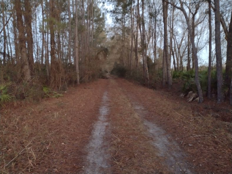
The Trail to Lake Butler
The trail continued as an unpaved roadway of top the old rail bed. After a few miles, it stopped becoming a road and was just a footpath. Because the grass was still frozen, my feet didn’t get wet from morning dew.
About halfway to Lake Butler there is a reroute out to highway 100 for about 2 miles, and then back. The detour out and back is an additional 2 miles. I can see the trail goes over a river, so I’m assuming there is no serviceable bridge and that’s why we have to walk along the road.
I consider taking my chances of continuing on the trail and dealing with whatever water I encounter. But there are several reasons I decided not to try it.
The first was that about 3 mi before the reroute, there was another river that had a bridge This one was only 20 yards from the road so it was easy to run out to the road and cross on the highway bridge and then run back to the trail. This Creek was wide enough that you definitely wouldn’t want to walk across it but you could if you had to.
If this first one is not rerouted, then the second one must be even bigger than this.
Reason number two is that if there is no traffic for that 2 mi section, then the trail will be even more overgrown than it currently is. After seeing what happened at the other end of the trail towards Palatka and the woods becoming so thick that it was impassible, I decided this was a credible reason to not try it.
And the third reason is because the waterway that we were crossing is called the New River. The New River sounds big. If it was called Possum Creek, then I probably would have dismissed it.
The roads leading from the trail to county Road 100 were not heavily trafficked. I was able to walk on the pavement 90% of the time.
The highway bridge over the New River was very, very long and had almost no shoulder whatsoever. It was not a pleasant crossing. The River itself at this point was about 20 yards wide, so it definitely would have been a wading situation.
Lake Butler
Coming into town, the trail became paved. It skirts from the south end of town to the west end of town. But I was interested in the Mexican restaurant on Main Street. So I took a detour just before City Hall to go grab lunch. It was nothing to write home about. Or blog about.
The next stop in town was the IGA supermarket. I only need two breakfasts, two lunches, and some walking snacks. I was also wanting some more instant coffee, but they did not have any that were suitable. I was also able to charge up my phone and battery bank for about 30 minutes while I repacked my food bag.
The Trail out of Town
The trail turned to grass again right after the IGA supermarket. And within a few blocks it went from a grassy field to a forested track again. Only this time the forest was too thick to negotiate easily.
I could see from the GPS tracks that it looks like they started out with a road walk and then headed over to the railroad bed. So I walked along the road for about a quarter of a mile and then ducked in to the railroad track.
But the track even here was covered in trees growing up in the middle and downed trees and lots of vines. Another look at the GPS tracks showed that they were actually on the west side of the tracks and not on the tracks themselves.
When I went further away from the road, I could see that there was a mowed path between the property and the right of way. Okay so this will do just fine.
Within about a mile and a half, the trail on the side of the tracks basically disappeared. So I tried walking on the tracks for a while but it was just too crazy and too many vines and obstacles to negotiate. So I went back out to the road again.
The same pattern would repeat itself three or four times over the next few miles. I would see that the GPS tracks show that I should be on the other side of the railroad bed and not along the road. So I would go over there and find a small path but most of the time it was on private property and not the right away.
I eventually gave up on trying to find or follow any trails whatsoever. It was just easier to walk along the shoulder of the road for the 8-mile walk out of town. They shouldn’t even bother calling this section a trail.
Away from Town at Last
After the 8-mile road and jungle walk is done, the trail turns directly north. I will now be making my way to Olustee and the Osceola National Forest.
From the map it looks like we’re going to be doing road walking again, but when I get there I see that there is a trail that just closely parallels the road. This will do just fine.
It is exactly 5:00, so I would like to hike for another hour before finding a place to camp. There are pine trees all around and it looks like it will be easy to find a place. The only problem is the ground is also a little bit swampy, so it might be hard to find a dry place.
I met another hiker who is looking for a place in the pines shortly after I enter the woods. He is doing a section hike to get ready for doing the Continental Divide trail in a few months. I let him know about Chuckles and him just finishing the CDT a few months ago. The other hiker has not seen Chuckles, so I can only assume that he is behind me and probably staying in Lake Butler tonight.
Pick one Emotion
The morning went very well. It was very cool and relatively easy hiking, except for the state road 100 road walk around the river. So I’d like to pick something up beat.
But the afternoon s*** show of not being able to find a walkable trail really put a damper on what would have been a great day.
So I guess I need to pick exasperated.
The railroad out of town could make a perfect trail. All they would need to do is just cut down the trees and vines that are growing in the middle of it. The path is already set and there is an excellent foundation for an actual trail.
But the fact that the GPS tracks are going off of the right of the way and into private property is just insane. If they don’t want to clear the trail, or for some reason are not allowed to because the Florida Department of Transportation actually owns the land, then they should just make this section a road walk and not a nightmare of barbed wire and vines.
As a blogger, you know it was a bad day when you only took two pictures all day and only one is worth posting.
Recent Comments