Category: Pacific Crest Trail

Anything related to the 2650 mile Pacific Crest Trail, stretching from the Mexico border in California to the Canada border in Washington.

PCT mm 540.3 – The LA aqueduct

image

Walking along the open section of the Los Angeles aqueduct.

I woke up at 6, but the first shuttle to the store did not leave until 7, so I started packing and filling water bottles to get ready.  Everything was ready to go by seven.  So after hopping to the store to get a breakfast burrito and a few snacks, which included two bottles of squirt, I was headed out by eight.  I don’t know why I love grapefruit sods so much, but I do.

Buying the soda was another tactic just to get another bottle since there is a hot 24 mile water carry coming up and I needed one more bottle.

The smart thing to do would have been lounge around Hiker Town all morning and afternoon and set out at 5 or 6 PM.  But I was itching to get an early start and then find some shade to hunker down for siesta.

Leaving Hikertown the trail hugs property lines for about a mile.

The trail started along a field for a mile, then the open aqueduct for Los Angeles for about a mile, then the aqueduct turned into a giant pipe and headed straight uphill for about three miles.  Most hikers actually walk on top of the riveted pipe.  You can see mineral deposits all over the joints that leak and a million welded patches.  Then it turned into a concrete covered channel for a million miles.  Well, maybe not a million, but well over ten.  It was easy hiking on the concrete lid and would have been easy by moonlight.

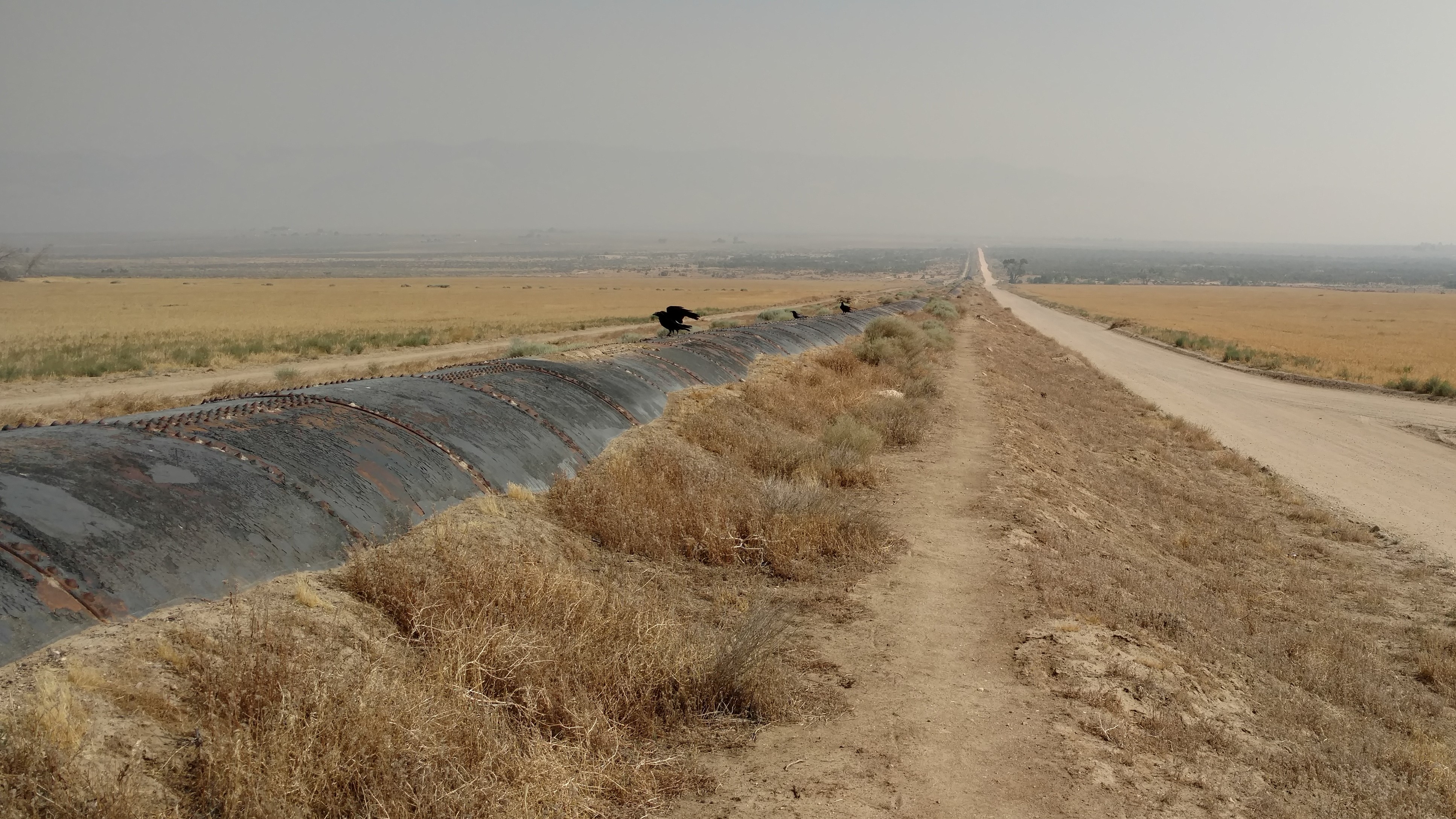
Half of the time I hiked on top of the pipe, and half the time on the path next to it. The horizon is about three miles away.  I hope that buzzard is not expecting me to drop dead.

An odd place to stop for a break, but the recliner looks so inviting.

Eventually the pipe turned to a concrete culvert with a concrete lid that looks like a road.

Even though I set out at 8 o’clock, the heat of the day was already present.  I decided to wear the shorts since it would essentially be a road walk with very few weeds and I wanted to be cool.  A nice breeze and the umbrella kept things comfy until about noon, when the breeze died down quite a bit.  I found one of these crazy cactus trees [Joshua trees] to get some shade under, but had to move several times as the sun shifted.  Without the breeze, it was quite hot.  I also noticed when I set out again, that my legs were slightly sunburned so I lathered them up with sunscreen.

Trying to get some shade among the Joshua trees to escape the heat of the sun.

I ate and stayed put until 4:30 when I decided I had enough and set out into the heat.  It wasn’t too bad and the aqueduct gave way to a wind farm.  Now it was the wind farms turn to go on forever.  You can see them easily way off into the distance, but they never seem to get any closer.  It was well over an hour before I felt that I was actually getting nearer.  There must have been three hundred of them and the field never ended.

Wind turbines appear on the horizon.

The only shade structure I ever encountered on the entire desert hike. If I could only have made it this far before stopping for Siesta.

It was well after dark before I finally passed the last one and was officially back into the hills again.  I found a decent campsite two miles from the only water source for the next two days and still within earshot of the wind farm.  Those things make a lot more noise than you would think.  It sounds like I’m near a highway.

Finally getting close to the windmills. They make a tremendous amount of noise this close up.

Hiking into the sunset among the wind turbines.

I only have 26 miles to Tehachapi and don’t want to get there until Sunday, so even though hiking at night in the cool breeze is fantastic, there’s no reason to hike late into the night.  I will get up not too early but be out by six and do ten in the am and ten in the PM, to put me only six miles from town.  That would be good, as I have a lot to do while in town.  I am planning on taking Monday off since it is the peak of the heatwave.

PCT mm 517.6 – Roads, roads, roads

image

Beautiful sunset along the road walk leading into Hikertown.

Today started with some relatively easy and slightly bland hiking, then got worse.  It started as a normal 12.9 mile morning on typical high desert canyon with a few more scrubby shade trees than normal.  The grade was pretty even all the way to the fire station where I stopped to make some burritos before hitting the road walk.

Nice morning hiking in the shadows with nice views.

A worn out shovel put back into service as a sign post.

The fascinating bright red bark of the Manzanita tree.

Yes, more road walks.  This one another fire closure.  I thought the road walk was just 16 miles, but it turns out that’s just to the intersection where you get a choice to go north or west.  The road walk ended up being a full 20 miles, so today was right at 33 miles.  Uggg.

The couple from Australia hiking in front of me on the way to the Rock Inn Restaurant.

This once used to be a large lake with a park next to it. Now it is completely dry.

I frequently would take accidental pictures while putting my camera back into my pocket. This one was interesting enough to save.

The good part is that 6 miles in there is a good restaurant to eat at and a convenience store if needed.  I ate with a couple from Australia that I met just before the fire station.  I did not leave the restaurant until 3:30.  After the first three miles or so after the restaurant, it turns to park land again, so you could stealth camp if you wanted to.  It was still early so I wanted to keep going.  I was pretty sure I could not make Hikertown hostel before dark, but I knew it would be close.  After eight miles from the restaurant it was all private property again and posted signs all over the place.  At that point I had gone past the point of no return.

At the 16 mile intersection, I could go left to the trail early, or go straight and hit Hikertown and be only a tenth from the trail.  I elected for Hikertown because it looked shorter there than the trail to the left and.

The sun was starting to set but I still had light.  I made the last turn with only one mile to go and the sun was behind the mountains now, but I had enough light to hike without a headlamp.  I made it to Hikertown at about 8:30 and boy was I beat.  I got a trailer to sleep in and a shower and made some rice to eat.

Hikertown is the most interesting place to visit. It’s a peculiar mix of discarded buildings, trailers, and campers. The permanent structures all have a theme to them to mimic a small western town.

The next section of trail is more roads then the Los Angeles aqueduct.  It’s a long straight hike with no shade and nowhere to camp.  I’d like to do it in one shot tomorrow, but know I won’t be able to leave too early.  But I’m still racing an upcoming heat wave, so I can’t take a day off just yet.  I might be hiking more at night, just not tonight.  [Post hike:  I found out that Robin left here about three hours before I arrived  This is the closest I ever got to him after losing my sunglasses.]

PCT mm 465.9 – Beam me up Scotty

image

The famous Gorn rocks in Vasquez Rocks Natural Area from the TV series, Star Trek.

This is not the usual landscapes I post, so what’s up with this pic?  You’ll find out later.

I didn’t get up too early this am, mainly because the clouds had rolled in and I was in the middle of them all night long.  I woke up about 11:30 and found the outside of the sleeping bag wet.  I was surrounded by a cloud and slowly getting damp from the dew.  There wasn’t much I could do, putting the fly on would just get it wet too, and it would take too long to get anywhere low enough to be out o the clouds.  I just rode it out and slept a little later to let it get a little brighter.

So when I did roll out at 5:30, I run across another hiker just 200 yds down the trail sacked out cowboy style – no tent, just a sleeping bag laid out on a sheet of tyvek.  He was soaked, too.

The clouds lasted most of the morning, but started to lift a little as I got to Vasquez rocks.  It’s a really neat place.  it’s an entire valley with rocks made out of other rocks.  The layers and stratification would keep a geologist busy for decades. I must have taken 30 pictures.  It’s definitely a place to come back to.

But getting there is interesting, too.  You pass through a very long tunnel under the interstate, which must be 80 feet above.  The tunnel is so long, you have to use your headlamp after entering about 30 feet or you will trip over debris and rocks on the floor.  Even though you can see the other side, it’s really dark in there and you can’t see crap.


Once you pass under the interstate, you are entering Vasquez Rocks Natural Area.

The canyons entering Vasquez Park.

The rock formations are all over the place as far as the eye can see.

Approaching the town of Agua Dulce off in the distance.

Once I got to the actual park itself, the rock I was looking for was quite easy to spot.  Many TV shows and movies have been filmed here, but the most famous is Star Trek where Captain Kirk fights a Gorn.  It felt really weird and eerie being there and imagining a film crew there.  Google Kirk vs Gorn to see a pic.  WordPress won’t let me attach one here.  [Post hike: I can post it after the fact pretty easliy 🙂 ]

Famous scene from the 1966 episode “The Arena” of the original Star Trek series.

I got in to Agua Dulce about 9:30 and went straight to the breakfast house – the Sweetwater Bar and Grill.  The Barbacoa beef burrito was heavenly and so was the fresh picante salsa to go with it.  That’s not just hiker hunger talking, it really was that good.  [Post hike:  Still the best breakfast burrito I’ve ever had in my entire life.]

I waited for the shuttle to Hiker Heaven, the local hostel.  I was there about 20 minutes when a man drove by in a gator and said the shuttle was not regular, just come over to the hardware store and have some free coffee and donuts.  So I sat there for nearly two hours shooting the shit with the men’s gossip league.  There were some interesting conversations, let me tell you.  I made a stop at the market to resupply in that time and then the guy in the gator finally just drove me to the hostel.  It was a mile away and I could have walked it in 20 minutes, but I had fun with the old timers as they gossiped about everyone who walked into the restaurant.

Once I got to Hiker Heaven, it was an operation, let me tell you.  The intro took 10 minutes.  They are extremely efficient at hosting very large numbers of people in an organized fashion.

I grabbed a laundry sack and towel and made a beeline to the shower.  It always feels good to be clean.  When you sweat a whole bunch, four days without one drives you nuts.  I can’t bathe every day like I could on the AT because I am dry camping where I have to carry every drop of water and it all goes to drinking.  Even dishwater from cleaning my cooking pot goes down the gullet (no soap).

I gathered all my laundry after the shower and put it in the bag and labelled it as instructed.  Then I grabbed a pan and Epsom salt and soaked my feet.  It was the first opportunity I have had to do that and it felt good.  I had some old callused skin that I wiped and picked off.  No serious blisters at this point.

It took a while for laundry, so I was able to recharge the electronics, check out the water report for the next hundred miles or so, and do some other chores.  I called the hardware store in wrightwood to see if anyone turned in my glasses but no luck.

I got a ride back to town as soon as laundry was done and I was packed.  I got dropped off at the pizza joint to have lunch on the way out.  A large pepperoni pizza and two slices packed out for dinner it a great way to leave a town.

I made it out at 3:30 and the clouds had broken, but there was a cool breeze, so I did not even use the umbrella.  More clouds rolled in later, but it should be a fairly clear night.  I wanted to make it at least ten miles out of town because I have another road walk due to fire closure tomorrow.  This one is 14 miles but has a restaurant in the middle of the walk.

Leaving civilization after about two miles along roads and I am rewarded with another great desert sunset.

I did not stay in town because I am trying to outrun another heat wave that hits on Monday.  In Agua Dulce it is supposed to get to 108, but the town I am going to be at on that day is supposed to be only 98.  I just want to get as far across the desert as I can before the weekend.  It is almost full moon, so if night hiking is needed, that will help.

PCT mm 418.5 – Road walk and poodle dog

image

Another undercast day in southern California.

I got up bright and early to make some tracks today and to be sure I was done with the road walking when it was still early and cool.  Since I was high on mount Wilson, I had a great sunset as well as a nifty sunrise.  The breeze died down in the middle of the night so I was alot warmer than when it was blowing while I was cooking and eating the night before.

All because of a toad

It was only a few miles before I hit the trail closure because of a rare toad in the area.  12 miles of trail are closed and substituted with a 7 mile road walk.  The road walk itself was quite nice.  In the two hours or so I was walking it, I probably saw only five cars.

A peaceful road walk with very little traffic.

The scenery was nice and the grade pretty tame.  A campground was five miles into the walk so I detoured to get water.  It took a while to find and I don’t think I was really using the official source, but it was water and I needed it.

Walking tall… On a road.

I was back in the woods long before lunch and stumbled on two other hikers who were both section hikers.  The trail here was an old abandoned road.  You could see chunks of asphalt here and there.  The trail was smooth and the grade quite mild again.

When we came to the private campground that sometimes has water, the owner was there and had filtered water for us and even cooked us hotdogs.  It’s always nice to eat something you don’t have to cook yourself.  He was there for the week with his son and a few other people doing maintenance on the structures.  We chatted a while and then set off again.

Another milestone – 400 miles done.

The afternoon was warm, but not hot and I took a short 30 min break to eat at 12:30 then again for an hour in the shade to nap at 3:00.  The area for at least ten miles around here had been burned and one of the nasty things that grows back after a burn is called poodle dog bush.  Weird name, weird bush.  It was all over the place and frequently right on the trail.

Poodle Dog bush is special because it has a toxin similar to poison ivy and oak that causes severe rashes if you touch it.

I am still wearing the long sleeves and long shirt to combat this possibility.  I am also carrying cortisone just in case.  There is also a lot of poison oak around here.  The one odd thing about poodle dog is that it is very fragrant.  It smells like skunked Canadian beer, and I like that smell.

The mild mannered poodle dog bush.

I ended the day a little early because I needed water to cook with and the only water for quite a while is at a forest service fire station.  They have a pit toilet, water, and a picnic table.  A perfect place to make a huge pot of spaghetti and chocolate pudding.  It’s 18 miles to the next water and there is another road walk specifically for poodle dog section that is really bad.  I think it’s about 8 or 10 miles of road walk.  If nothing else, it should make the day go by more quickly.

A typical southern California view on the Pacific Crest Trail.

PCT mm 446.7 – More road walks

image

Setting up camp on a ridge line with a fantastic sunset.

Camping at the forest service fire station kept me up all night for some reason.  I had a good spot, it was not too windy, it was not noisy, but I just kept waking up all night long.  I got a late start at 5:30 but went back for more water and to cook some black bean soup I should have eaten days ago.  It was not too good.  Whenever plentiful water is available, I try to cook.

Early morning through a grove of oaks.

It was only a few miles from the fire station that the poodle dog bush bypass began.  It followed the road parallel to the trail for six or seven miles.  There was poodle dog all over the road even.  There were at least two back country campgrounds that were basically now deserted because of the road closure.  [Post hike:  This area was cleared of Poodle Dog bush and this section of trail reopened in 2017.]

This is now an abandoned road with abandoned back country campgrounds.

Even the old station with its burned out buildings was very eerie.  I’m not sure how many people lost their lives in that fire, but it was enough to erect a monument to them.

The monument to the 2009 station fire that was the worst in Angeles county.

The abandoned station with its burned out buildings.

What was once a low forest is nothing but scrub now.

The trail after the road walk still had some poodle bush, but just the normal amount.  I hit the ranger station 17 miles from the fire station at about 1 PM or so.  There were three other hikers I had not met yet already there, and one more showed up shortly afterwards.  The caretaker there (another abandoned campground) was supplying bottled water.  I cooked a big lunch and rested my feet for a few hours.  I’m starting to use the flip flops as much as I can now to let my feet rest and dry out.

I headed out at three to set off for anywhere past the KOA campground eight miles ahead.  I was able to find a nice high spot overlooking some interesting rocks and get there before 7:30 and had plenty of time to make camp, clean a bit, and cook a big dinner.

These rocks are made up of sediment and other rocks.

I have only about eight miles to the next town, Agua Dulce, where I will probably take a nearo to take care of chores that need to get done. I would normally be there by 8 or 9 am, but six miles from here are the Velasquez rocks, where several Star Trek episodes were filmed.  I have an idea I will hanging around there quite a bit taking pictures.

PCT mm 387.8 – The big climb out of town

image

Whispy clouds in the next valley.

I purposely slept in late so I could catch breakfast at the coffee shop and wait to here from Aaron to see if he found my shades or not.  If he found them, I would stick around until he got in, otherwise I’d head out.  I chatted with my host a few minutes then headed to town for vittles.  It was a five block walk to The Grind.  Town was mostly dead, there were only two others in the shop and no other shops were open.

I ordered an oatmeal and bagel along with my coffee.  All three were great.  I realized after I ate that I was still hungry.  I should not have skipped dinner.  I ordered a breakfast sandwich and honey bun as well.  They were also good, but I saved half the sandwich to pack out for lunch.

The Grind had many photo albums of hikers they had taken pictures of over the years.  I thumbed through them while waiting and saw some interesting faces.  I was hoping to see a hiker that I had met on the AT, but no such luck.  I noticed one guy in a red vest showed up in multiple year albums, sometimes solo, sometimes with another hiker.  He was a red headed white guy with dreadlocks – he stood out.  [Post hike: I DID end up meeting this guy later at Kennedy Meadows – and mentioned seeing him in the photo albums.]

I headed back and packed up and went back to the hardware store to hitch.   I tried to make eye contact with every driver that passed by to increase my odds of getting one to stop.

Most of the cars passing by were Sunday-going-to-church-I’m-too-dressed-up-to-pick-up-vagrants drivers with their families, so I was worried it might be a hard hitch out of town.

This one also took 30-45 minutes and the guy who picked me up also turned around to come get me.  He also wanted to talk about the trail.

Ponderosa pines leading up to Mt Baden Powell – named after the founder of the Boy Scouts.

The trail out from town was more of the same as yesterday – ponderosa pines.  About five miles in we hit the approach to mount Baden Powel, named after the founder of The Boy Scouts.  My host had told me there were 40 switchbacks during our chat this morning, so I started counting them right from the trail head.  Part way up another hiker said there were 42.  I was determined to see who was right.  I counted the segments all the way to the peak and came up with 41, so I think my host was right – there are 40 switchbacks up that bugger.

Still a long way from Canada.

The trail was crowded, too.  There were perhaps 40 cars in the parking area.  I passed at least 50 people on the way up, and was passed by no one.  I’m starting to get my legs.  I also got a text from Aaron while on top – he could not find my sunglasses, booo.

The view from Mt Baden Powell.

The view up at the top was nice, but not spectacular.  I had heard there are great views of Los Angeles, but the entire coastline was undercast, so all I saw were the tops of clouds and the mountains 5-10 miles away..

Sunset from Mt Wilson.

About a half an hour after getting up there, Peter from Poland showed up.  He is now officially Peter pan.  We hiked most of the afternoon together and are both camped on Mt Wilson, but on different sides.  It is very cold and windy up here.  I was cold while making dinner but the bag is keeping me toasty.  We shall see how cold I am in the morning, though.

PCT mm 369.3 – Wrightwood

Cajon pass is now blanketed in fog.

6-11-2016

In the morning I waffled back and forth on whether to backtrack 7 miles to try to look for my glasses or not.  In the end I decided it was wisest to not try to do that and to rely on Aaron and Stiff to look for them as they came up behind me.  After all, I did have a backup pair and I can use my regular glasses most of the time unless it’s really bright out.

I played leapfrog with Tule most of the morning and we were both surprised to find another water cache not on the water report that was well stocked.

Using the Guthook app that shows way more campsites than the official data book and has up to date postings on statuses as well as pictures.  It has been the most reliable thing to use so far.  It’s the best $25 I have spent on the entire trip.

The terrain at the beginning to f the morning was more desert but the last five miles turned to ponderosa pines again and it was a nice hike into town.  I did not seem to have much energy most of the morning and I think it’s because all of the extra running back looking for my glasses from the night before and not getting enough to eat.  I ate a full dinner but I guess I needed more.

It took at least 30 or 40 minutes to get a hitch into town.  Another hiker I had passed that morning showed up and we hitched together.  Turns out he is also from Florida and also hiked the Appalachian Trail in 2008.  Small world.  His name is Achilles.  The guy who picked us up was interested in doing the PCT some day so he picked our brains all the way into town.  He had actually passed us, then turned around to come back to get us.  And he wasn’t even going all the way to wrightwood.

Once in town I went straight for the hardware store to pick up my resupply packages.  That a small section of the store dedicated to PCT hikers and had a two page flier with trail angels names and numbers.  I took a photo and headed straight to lunch.  Tule texted me where he was eating and Achilles and I joined him.  After lunch (burger, fries, salad, and a beer) we started calling trail angels to see who had room.  I found one on my second call and she had room for two.  Tule already had one so Achilles and I took it.  She had a pop-up camper for us to use.  It was perfect.

Achilles showered and went to town, while I did laundry and repacked from the supply boxes.  One of the things I had Karen send me was a book on PCT planning that didn’t arrive until the day after I left.  She said it was big and wouldn’t fit so I had her take out a days worth of food to fit it in.  She was right, it was big… And heavy.  Being Saturday, I couldn’t mail it back or anything so I started reading it.  It has some useful info and I took photos of about a dozen key pages.  I still have not finished planning all of Oregon and Washington so it will still come in useful.  The other thing I wanted it for was town maps.  I looked through all the towns I have already been through and came to the decision that the Guthooks app is just as good, so I did not photograph any of those pages.

By the time I had my shower and laundry was done it was close to 9 and I wasn’t hungry, so I did not go out to dinner, I just ate a few cookies and went to bed.  It felt really good to be clean and in clean clothes.  I slept well and didn’t even use earplugs.

PCT mm 353.9 – It’s all about McDonalds

Where the abandoned Route 66 crosses through Cajon pass, nirvana awaits.

6-10-2016

I slept in a bit then headed out about 6 and visited with everyone as I passed them.  Everyone was focused on McDonalds.  I was trying to get there after 10:30 but it was just too hard to go slow.  And I tried.  I dilly-dallied and checked out all the views and scaled down a steep slope to retrieve a mylar balloon (second of the trip).  Much of the terrain was extremely steep and extremely crumbly rock.  I was surprised how close they took us to the edge.  I would not be wanting to ride a horse.

Robin gets close to the edge – it’s a few hundred feet down.

We did end up getting to McDonalds at 10:00 so I broke down and ordered a parfait and an orange juice and a coke.  That held me over for 30 minutes until lunch started.  I found an outlet to charge devices and got the phone and battery pack pretty full.  Then lunch was a double quarter pounder with fries and a shake.  We were there until 1 and I must have had eight cokes in that time.  I have never had that much coke before but they just kept going down smoothly.

Ice cream for dessert in the desert.

Both arriving and leaving McDonald’s we could get a great view of Canon pass.  The interstate is split and two double mainline freight tracks go straight up it.  All the trains had for or five engines on the front and some in the middle or rear.  From my campsite I can see the interstate and it’s steady stream of traffic to and from Barstow CA.

The climb out of town is 27 miles without water and 5000 ft of climb.  Cloud cover cooler things off a bit, but it was still a hot climb out.  I took a short break at about 5 miles out and think I left my sunglasses there.  I did not notice it until I was about 10 miles past, and actually dumped my pack and ran about 4 miles back to a second spot where Robin and I stopped later.  As silly as it sounds, running without a pack felt good.

I am camped somewhere in the middle of that backtracking and contemplating running farther down in the am to where I think I left them.  Another hiker (Tule) came by as I was about to settle down for the night and texted to two other hikers who have not come up yet.  I don’t know if I should cross my fingers and rely on them, or suck it up and run an extra 14 miles.  And did I mention I’m on limited water…  It’s going to be a long night thinking about it.

The really funny thing is that I found a pair of sunglasses as I started backtracking to look for my prescription glasses that I left at a rest stop earlier in the day.  The trail provides exactly what you need exactly when you need it.

The sunglasses I found are not prescription.  I’m not totally hosed, but I wear mine ten hours a day and have grown quite accustomed to having them.  I’ll keep asking around if anyone has run across them.  I am just very fortunate to not have to continue through the desert without sunglasses.  The desert reflects a lot of light and are pretty much required equipment for me.

Cajon pass is a constant stream of cars all night long. This is the main route into the Los Angeles valley. They sleep less than New York, apparently.

PCT mm 333.8 – Swimming finally!

What looks like a large dam is actually for flood control Yeah, it floods here. Seriously.

6-09-2016

I got up early and was on trail by 5 am because I had about 18 miles to go to the picnic area with water, shade, and swimming.  I passed the other crew I was with yesterday at about 5:20 and they were all still sleeping.  Late risers 😉

The rest of the canyon was pretty uneventful.  There was old rock work dated from 1927 along most of it and it was still in decent shape except for the graffiti.  Apparently deep creek has a history of flash flooding because they built an entire flood control dam to control it.  The spillway itself was at least 50 ft high.  That also explains the enormously high bridges that had built across the river over the previous 15 or so miles.

The morning started out cool, but got hot pretty quickly.  Every day the forecast says the max temp will be only 87 but then at the end of the day they report that it got to 100.

I took an early lunch break around 10 when I found some good shade trees and made a peanut butter, honey, and chili cheese Frito wrap.  I’m already sick of peanut butter and honey, but the fritos add that extra oomph that make it palatable.

There must be a large quantity of water somewhere around here.

I got to the first picnic area which had pit toilets and shaded picnic tables but no water.  It was very tempting to stop there since it was already one, but the lake water was greenish and I wanted a better spot two miles further, so I pushed on.  I got to the main picnic area about two and hit the toilets first.  Flushing toilets and running water, ahhhhh.  It’s the simple things.

Water at last! And lots of it.

I set up under the main pavilion which was vacant and tanked up on water and prepared to cook some soup when in rolled Robin.  He had the same idea as me… Go for the good picnic area.  We are some lunch, rested a bit, then went swimming for about 5 minutes.

The water had lots of plant life in it so it was not super pleasant, but boy did it feel good.

We dried, dressed, and both headed out around 5.  We were only 13 miles from I-15 which has a McDonalds and we both want to hit it for lunch.  I only ventured out 5 miles and camped and Robin went about 8.  He will probably dilly dally a bit before heading out tomorrow, and I will too, since I don’t want to get there before they serve lunch.  I’m not a fan of McD breakfast.  8 miles away and I can already smell the big Mac.

My typical camp setup in the desert – tent body to keep critters out but let the breeze in. Kitchen off to the side and laundromat everywhere.


PCT mm 310.0 – Water everywhere

A group of hikers taking a lunch break.

6-08-2016

[Post hike:  The hiker on the far left is Stiff – I don’t know how far he made it, but I knew where he worked in Asheville, NC and told him I would visit him.  Karen and I did so the November after the hike.  It was great seeing him.  Sitting up is Aaron, who is from Seattle and made it through Oregon before having to go back home.  In the Red is Tule, who I left in Wrightwood and he leapfrogged me when I had to leave the trail in Portland for the wedding.  We kept in touch until the end, when he finished a few days before me and we missed each other by only a few hours in Mazama, WA.  I met the three of them in Warner Springs and they were there when I was christened as Dirty Gil.  Tule is the reason the name stuck.  Robin is on the right – I chased him from Wrightwood to the Sierra, where I lost track of him as he probably assumed a trail name after that.  I was within two hours of catching him at Hiker Heaven and a day away at Kennedy Meadows.  I have no idea if he finished or not and have no contact info for him.]

Most of the day today we have been walking a canyon along the same river.  Much of the time we have been high above it, but several times we went right down to it.  And when one spot opened up to a sandy beach, it was too much to resist.  I think I got there about 11 am and others kept filing in.

I left at 3, trying to get to the next interesting spot, hot springs, by 6 PM.  I didn’t get there til 7 and it was quite crowded.  The canyon provides very few places for camping, so it was either go a short day or a long one, and I chose long.

Where we stopped for lunch, it was too shallow to swim, but I did go splash around.

Several miles later I did find a good swimming spot, but could not afford the time to do so.  The same with hot springs.  There’s an actual hot springs that spills into a rock hot tub then into the river.  There were at least fifty people there all camping out, even though camping is not allowed.  It is also clothing optional, but none of the bathers opted for clothing.  Again, no time to go swimming.  Also, no time for pictures.

This stream goes on for miles and miles. There is water, but it is very far down and very hard to get to.

The rest of the day was hiking along the river and crossing back and forth several times.  The park service has installed several high and sturdy bridges across the canyon.  Makes for good views, that’s for sure.


One of the many bridges across the canyons.

We pushed on another few miles and I stopped to camp on an old abandoned trail and the others went on another mile looking for a better place.