Day: July 8, 2016

PCT mm 895.4 – Full belly

image

Have I mentioned that there is a large lake in every meadow in the Sierra?


The crowd around the fire last night stayed up til 11 so I listened to music for an hour to drown them out and then in the morning again when I woke up at five because the store and restaurant didn’t open until 7 am.  I got up at 6:30 and started packing and was able to get 90% packed by the time the restaurant opened.  I had breakfast with another hiker from Portland who did Oregon and Washington last year and is just doing California this year.  The breakfast burrito at VVR is top notch.  At the time I was thinking that I was going to order two breakfasts but just one burrito did the trick.

I was able to close out my tab and buy a few last minute food items and finish packing before the 8 am ferry was ready to roll.  We set out across the lake at 8:30 and I was back on the PCT right at 9.  And of course the trail would begin climbing immediately.

Most of the day was uneventful.  Only one pass for the day, very little snow, the usual number of streams.  The burrito held me well all morning so I did not break for lunch until 2.  I loaded up on water and made some lemonade.  The only excitement of the day was while crossing a stream on a log that was wet, my foot slipped in the water and then the other foot of course.  I cracked one of my poles while trying to keep from face planting in the stream.  It’s still usable but will no longer collapse.  I don’t know if the warranty will cover this kind of damage, but I’ll find out at the next REI opportunity.  I know Leki covers damage like this.

The terrain is a bit rocky and steep as we head towards Red Meadows so finding a campsite is not as easy as other places.  I stopped a half mile before my intended destination because I found a nice soft flat spot without too many mosquitoes.  A bird in the hand, you know.

I am now 11 miles away from Red Meadows, where they have a small store and restaurant and have a bus that goes to Mammoth Lakes every 20 minutes.  This is where I hope to finally get cell service.  I should be able to get to town well before lunch if I leave early in the morning.  There are two hostels and laundry, but I’m not sure about the restaurant situation.  They have a full size grocery store and a movie theater.  Now that I’ve slowed down a little bit with the VVR side trip, I don’t feel the need to take a full zero in Mammoth, but we’ll see.  After all, they have a brewery, too.

PCT mm 878.7 – Vermilion Valley Resort


Waiting on the shoreline for the ferry to VVR, but the real landing is on the other side of these rocks and I almost missed the last ferry of the day.

I get to actually see civilization today.  Even though I have enough food to make it to Reds Meadow and Mammoth Lakes tomorrow, I’m craving real food so I’m taking a side trip to VVR.

I tried the fleece under the back trick last night and it worked out splendidly.  I slept well and could even sleep on my side with the fleece still underneath me.  I woke up at 5am and decided to listen to music instead of trying to sleep in.  Pink Floyd Animals.  Nice and mellow for my mountain lake campsite.  When I did get up thirty minutes later, I was not as stiff while moving around.  I got going at 6:30 and had no back pain.  Voila.  I did have a small twinge of pain around 10:30 while putting shoes on after a river crossing, but it went away in ten minutes or so.

Every valley in the Sierra has a big lake in it…. and mosquitoes.

About those river crossings… There’s usually twenty to thirty small streams to cross every day, and rarely a big one you need to actually wade.  Well today there were three crossings that required wading and I didn’t want to have wet feet all day so I took my shoes and socks off for all three of them.  They were all very fast flowing and about mid thigh deep.  Even with poles it was a chore keeping balance against the current.  And the water was ice cold to the point of causing physical pain after about ten seconds, but the crossings took thirty plus seconds to complete.  About ten seconds after you get out the feeling comes back and you feel refreshed for about twenty minutes afterwards.

Small snow fields like this add an interesting twist to the day.

There were two climbs of the day that were not too bad, but what I was really looking forward to was getting to Edison lake where I could catch the ferry to VVR.  The picture is from the ferry landing site.  They run two scheduled ferries at 9:45 and 4:45.  The ferry site is 1.5 miles off trail and quite a pleasant hike.  I got there at 3:30 and found that the ferry had just been there just a few minutes before.  I could hear the boat motoring away.  Darn, could have gotten there earlier.  No worries, find a nice rock and listen to tunes.  AC/DC High Voltage this time.

About 4:45 I decided to look around.  To my horror, the ferry was a quarter mile away and loading passengers.  I hauled ass and managed to get there just in time to grab the last seat on the last ferry.  That would not have been good to miss the boat, as the trail there is five miles of ups and downs.  If that had happened, I probably would have bailed out and just headed on to Mammoth Lakes.

Riding in the ferry to VVR for a hamburger and beer.

But I did make the boat, and I did get to VVR and I did get a hamburger with fried jalapeños on it.  Pure gastronomic bliss.  A soda and ice cream coated the belly as well.  This place is still out in the middle of nowhere and has no cell service or wifi but they do have a computer you can use for 30 minutes for $5, so I was able to send out a quick email to let the family know I am still alive and make a quick blog post telling the same.

Mourning the loss of this giant tree. Actually, just avoiding mosquitoes.

I talked to quite a few people, too.  A guy had been hiking with his son here earlier in the week and brought his entire family back out just to talk to PCT hikers.  Two of his kids were interested in hiking the PCT so they were out doing reconnaissance.  The PCT hikers that are here are a new batch for me, so it was nice to meet some new faces.  I have not seen any of the hikers from Kennedy Meadows here.

The store opens at 7 am tomorrow, so I will grab a quick breakfast and try to catch the early shuttle at 8 am so I can get a good chunk of the mileage to Mammoth Lakes out of the way tomorrow and have an easy day in the following day.  I was able to score four packets of tuna from the hiker box so I don’t think I need to buy any food from the store tomorrow.

PCT mm 864.2 – An easy day

image

A small feeder stream about a half mile before crossing Evolution creek.

My back was pretty sore when I woke up and I didn’t get much sleep because of more apnea episodes, but I think I might have that licked.   And for the first time in a while, I did not ascend a snow covered pass, or any pass, but I am close to one that I will go over tomorrow.

The last few days my back has been sore if I bend over for too long and has been stiff in the morning.  I have had back trouble for 25 years, but it usually has not bothered me while hiking until now.  I have some guesses of what it is and what it isn’t.  I don’t think it’s the extra weight of the bear canister and snow gear.  I’m carrying less water and I’ve carried more weight before.  It could be accumulated stress of hiking, but I don’t think so.  It could be that I’m sleeping on a less supportive pad.  This thing does not give much support.  I have been sleeping more on my back than side lately, so maybe I need something under my lumbar.  I am trying putting my fleece pants under my back tonight.  It could be the poles.  I have been using them all day for the last week or so.  Without poles I can shift the pack around on my back in ways I can’t do while using trekking poles.  If the sleep changes have no effect, I’ll try that next.

On to the apnea.  I camped pretty high last night – 11,200 I think was the altitude.  Shortly after going to bed I began experiencing the episodes and finally about midnight I had an idea.  I was in the tent with the vestibule zipped up.  I have a double zipper where I can unzip it from the top to make a chimney to ventilate better.  I did that and then unzipped the screen enough to stick my head out.  After fifteen minutes of that, no episodes.  Plus I noticed it had gotten cold enough by then to drive the mosquitoes away so I just unzipped the whole netting and pulled it back.  That seemed to do the trick, so I took another sleep aid and went to sleep quickly.  I put my fleece over my head so the sun would not wake me up and that seemed to do the trick.  So basically, the higher the altitude, the more I am essentially suffocating myself with the tent all zipped up because the CO2 builds up inside the tent.  Easy solution if there are no bugs.

Entering the John Muir wilderness area. There’s not much difference here between a wilderness area and the normal National Parks on the PCT – they are both equally rugged and both well marked. On the AT, they are easy to tell apart and getting lost in a wilderness area is a normal occurrence as the trails are much less well marked and its very easy to go down a false trail.

So with the lack of sleep and the hard day before, I let myself sleep in as late as I wanted.  Which turned out to be 6:30.  There was a lot of dew and even some frost, so the later start allowed me to be able to dry things out before packing up and leaving.  Even with that, I still got out at 7:30.  It was pretty rocky and with my stiff back, I was not very comfortable at all.  It was slow going and one crossing early on I had to take my shoes off and that aggravated my back all over again.  It wasn’t until close to noon until my back felt better.  That’s one of the reasons I’m experimenting with sleeping first, because hiking does eventually make it feel better.

Can you tell the difference between lake and sky? It’s hard to tell sometimes.

A gentle breeze on this lake gives away which is water.

The highlight of the day was crossing Evolution creek.  It’s supposedly the toughest crossing so much so that they have made an alternate route that crosses at the meadow where it is much wider and not as deep.  Every south bounder I saw today I asked if they took the alternate route.  Every one of them said yes and when I got to the intersection, the normal way was blocked off with logs.  That settled that.  The picture is from the evolution meadow, but that was a much smaller feeder than the main stream.  When I got there, several people were there and had just crossed.  I decided to take my shoes, socks, and pants off and safe across in my skivvies.  It was about 50 yards wide and never got over mid thigh.  But even that shallow, it had a lot of force pushing me downstream.  They should probably make the alternate be the permanent route.

After crossing, I sat in the sun to dry off and talk to another PCT hiker who crossed just after me.  He has also hiked the AT, and we talked some about that.  But what we mostly talked about was food.  I was running a little low, to the point where I will probably stop at Vermilion Valley resort tomorrow, but he was flat out of food.  He was headed to Muir Trail Ranch eight miles away to see if he could raid their hiker box.  I saw him later in the day and he was able to get some oatmeal and noodles.  So he should be set for VVR.

Camping next to water is a recurring theme in the Sierras. It’s hard to find a campsite without it.

From about three o’clock onward, our downhill turned to an uphill.  We now begin another ascent of another pass.  There were camping spots a few miles short of the pass, so that was my goal.  The first one did not look good, the second one riddled with mosquitoes, so the third one it was.  It is overlooking the last lake before the pass and has quite a few mosquitoes, but is better than the other spots.

PCT mm 842.6 – Let’s call it a snow day – Muir pass

The hut atop Muir pass is considered an emergency shelter, but it’s pretty swank.

Another long day today.  I went over Muir pass towards the end of the day and it was a long and rough five miles over the pass.  I intended to go another mile to a campsite but this spot next to the river overlooking Muir pass looks good enough to me.

I slept like a baby last night.  I don’t think I awoke once until 5 am.  I lazed in bed for another half hour before getting up and I was on the trail at 6:30.  It was a long and steep descent into the canyon with lots of large rock steps.  They’re not any more fun downhill than uphill.

Rise and shine! Early morning is the best time of day to hike.

Once near the bottom of the canyon it was a nice densely forested are with lots of streams and a meadow that was so nice I wanted to stop and camp at 10 am.  The first five miles up the other side were just as nice and there were only small sections that were steep.  No more than a quarter mile before it tamed out for a quarter mile.

Streams like this are impossible and dangerous to cross without a bridge or substantial log..

Streams like this are a piece of cake to ford.

I love hiking among the trees where their ample shade can keep the direct sun off of you.

Tree/meadow combination terrain is hard to beat – shade plus a view.

The last four miles or so to Muir pass were pretty brutal, though.  It’s not that it was steep or rocky, but that there was so much snow all over the place that it was hard to stay on trail.  I know at least one full mile of those four I was not on trail.  And then when I would find the trail, there would be no footprints in the snow.  People were making their own trails where ever they wanted to.

Hiking along this stream increases anxiety as you know eventually you will have to cross it.

Some of the snow was deep and it was thoroughly exhausting to slog through.  I put on my microspikes pretty early into the snowfields which helped with traction, but the straps trap snow and your feet get very wet very quickly.  I wasn’t worked about frostbit because it was sixty degrees, but my toes felt frozen.

Some of the tracks across the snow were quite dangerous, too.  I saw at least three ice bridges where there were tracks on top of them.  An ice bridge is when there is a thick blanket of snow, but melting snow has flowed underneath it such that there is a smaller layer of snow with an air gap below it and run ng water below that.  Some of them were small, and not that dangerous – perhaps a three or four foot fall into six inches of water with only one foot thick of snow to support you.  But one was huge and scary – four feet of snow over a rushing rapid that was at least a fifteen foot drop into four or five feet of water moving very rapidly.  I did inadvertently end up going over there be by accident.  I didn’t realize it was an ice bridge until I was already half way across.  You could not see the running water from where I started, but you could see it half way across.  I stepped very gingerly for the ten feet or so I was at risk.  It would have been about a four foot drop and I guess I had about three feet of snow supporting me.  I used my ears as well as my eyes after that.

This is a very dangerous snow bridge over a 20 foot drop where several hikers have been walking straight across the top of it. Not me.

I could see people coming down as I was going up and could tell that they were nowhere near the trail. I just kept following trail until I lost it, then check with the GPS to see which direction it was from me, then bushwhack back to the trail and repeat.

I got to the top about an hour later than I was expecting and was glad to get there.  At the top is a round stone shelter built in honor of John Muir.  Even the roof is made out of stone.  It had a fireplace but it was bricked over.  There’s not a tree for two miles of this thing so it’s probably best that it’s shut out to keep the wind out.  I expected it to be windy, but it was actually a very nice day with just a gentle breeze.

The last snow climb up to the hut at Muir pass. You can clearly see what a sun cup is in this picture.

People I had met going southbound had mentioned the climb up would be long, brutal, and snowy.  But they all said the North side was a walk in the park.  Boy were they wrong.  I had a similar experience losing the trail and not seeing footprints where they should be.

Plenty of snow on the north side of Muir pass and very indistinct trails.

It was five miles down to the nearest camping spot and I wanted to get there with enough light to do all the camp chores.  I had enough energy, but it took forever with the navigation problems and dodging water and mud.  I found a closer spot about 7:45 so I will stopped there and had just enough time to get everything done.

A nice camping spot on sand and gravel with big slab rocks to sit on and cook. This picture is posed – I cook and leave the bear canister about 80-100 yds from the tent to keep food smells away from where I sleep. But I sit on the bear canister as a stool while I cook.

I will try to sleep in tomorrow and relax a little more.  I’m not sure what’s in store yet other than the largest river crossing of the trip.  I’d like to make it a shorter day to rest up a little, but these passes more or less dictate where you can and can’t stop.  I hope I can stop in the middle of a canyon for a change instead of rushing to get out of one and into another.

PCT mm 819.4 – A very long day – Pinchot and Mather passes


I love the early morning light for hiking. Hiking is the reason I am a morning person now.

I got up on time and was out hiking by 6 am and hiked until 8:30.  I wanted to be able to tackle both Pinchot and Mather passes today to avoid making it a short day.  The passes are so high, there’s usually two or three miles on each side that are not suitable for camping.

It was either stop short, or go long.  The day went well enough that long was in the cards.

First up was Pinchot pass.  From where I had camped at Rae lakes just beyond the previous Glen pass, it was all downhill for about five miles.  At the bottom was a suspension bridge that was quite shaky and rickety and also very high above the water.  I could not look down or out at the river.  To make things worse, some of the boards were loose.  I was glad to be across.

The suspension bridge for hikers – horses have to go downstream and ford across.

Backwoods comedy.

Then the grueling climb for five miles began.  I had to climb back up 3000 ft but what made it difficult was the trail itself.  The trail had lots of oversized water bars and oversized steps that really take the juice out of you.  I had to stop about half way up to make lunch at 11 am.  I was just totally out of energy.

A typical stream crossing in the Sierra can be easier if there’s a log across it.

Lunch did pick me up a bit.  The trail was still difficult, but I had more energy to tackle it.  Like all passes, the last mile is switchbacks straight up a cliff.  I got to the top just before 2 PM, which is the latest time I could get there and still have a chance at getting to Mather pass.  There were four JMT (John Muir trail) hikers at the top and we got to talking about what each of us could expect ahead.  Since we were going in opposite directions, that was easy.  When everyone is headed north, you can’t get that kind of intel.  They told me the South side of Mather was plain switchbacks, but the North side was a landslide and full of snow.  That could make getting to camp interesting.

The JMT and PCT follow each other for about 180 miles.

The nearest camp was 2.5 miles on the other side of the pass, and 2 miles before the pass.  Those were my two options.  If I could make the peak by 7:30 I should be able to make the far camp just about fifteen minutes before dark.  Which meant I had to make the first camp by 6:30 to be able to make the peak by 7:30 and so on.

Water is everywhere in the Sierra and never hard to find.

The descent from Pinchot pass was not too difficult, and only about 2200 ft instead of 3000 ft.  There were lots of stream crossings there, and pretty much all day.  Possibly over twenty of them.  Most of them have rocks that you can hop across, some you have to hunt up or down river for a better crossing (like a tree across the stream) but two of them I had to take shoes and socks off and wade across.  It gets old after a while.

A large log makes a stream crossing easy peasy.

About half way back up the ascent to Mather pass, I took another break to eat a snack and make some coffee.  Coffee really does work.  I was energized all the way up to the pass.  I got to the first campsite about fifteen minutes after my cutoff, but felt so good I pushed on anyway.  I ended up hitting the top of the pass fifteen minutes early, so I had a light snack and some water before heading down.

A hiker soaks in the view before heading up Mather pass.

The north slope had lots of switchbacks like the South side, but not as steep.  What it also had was snow.  Lots of snow.  Tracks went everywhere.  Some people glissaded down and then went cross country to get back on trail.  I didn’t want to get wet or go cross country so I stayed on trail as best I could.  There were so many sections of trail covered in snow that it was hard to figure out which way to go.

It’s hard to get tired of the SIerras, but they sure do make you tired.

The climb down took longer than I expected because of the navigational challenges and also because the trail was full of loose rocks.  I could see the lake where the campsite was as soon as I hit the pass, but it just didn’t seem to be getting any closer.  But eventually it did arrive.  There were other campers at the site and they were already in bed, so I quickly got water, set up the tent, then cooked dinner.  I had enough light for everything but making dinner, so I did that by headlamp.  It’s been a long day, so dinner was good and let’s hope sleep comes easily.

The many passes in the Sierra give outstanding views in every direction.

PCT mm 794.3 – Forester pass and snow

image

Looking up towards Forester Pass, the highest point on the PCT at just over 13,000 ft.

What a day today was.  Two big passes to cross and lots and lots of snow.  It just keeps getting better and better.  It was just shy of a 20 mile day today, and every single one of those was earned.

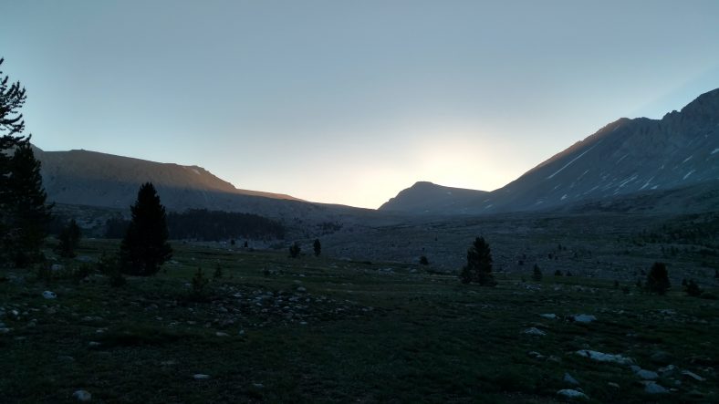
Hello, Mr Sun. So glad to see you today.

I woke up at normal time and was off at 5:45.  I had about five miles to Forester pass and about 2200 ft of climbing.  I camped at 11000 ft, which I did a few nights ago as well, but for some reason last night I was having a few hours of apnea where I would feel like I was not breathing and take a big gasp of air.  It happened off and on all night.  It’s annoying when it happens because it makes you wide awake.

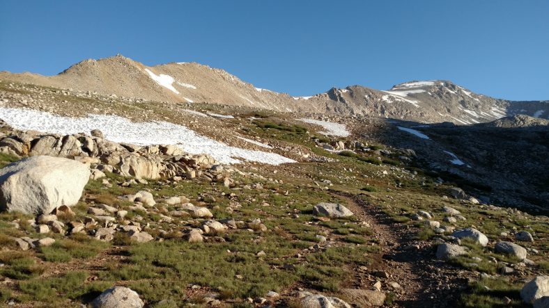
The approach to Forester Pass is an enchanting alpine hike.

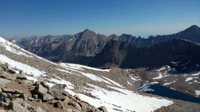
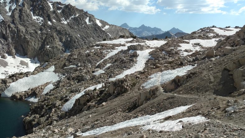
The first half of the climb was a lot more gentle than I thought.  There was very little vegetation so the views were outstanding.  About half way up it flattens out into an alpine tundra like terrain with rivers of melting snow all over the place.  The last mile or so is switchbacks all the way up to the pass.  The little snow fleck towards the left of the picture is Forester pass.  Yes, I hiked up the side of that cliff to get up there and over the back side.  The route switchbacks up the mountain on the right, then crosses the snow field in the chute and crosses the pass from the left.

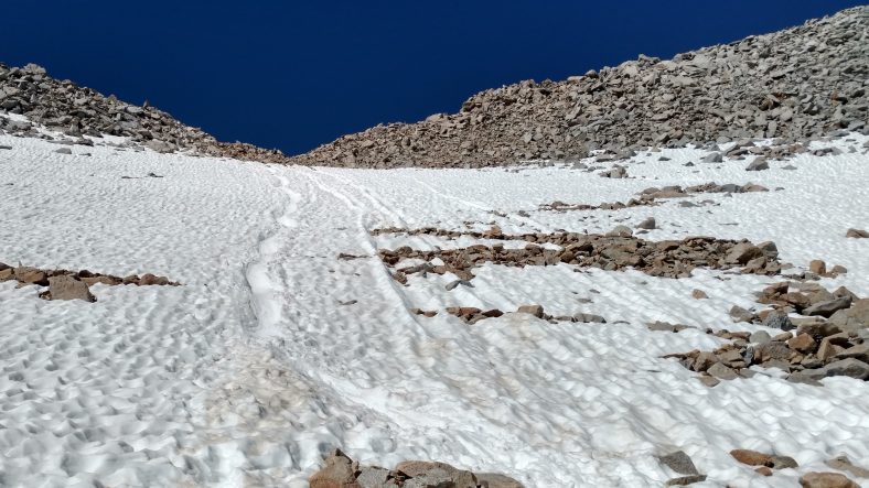
As you ascent up to the pass and look back, you can see just how much snow there really is.

The switchbacks up were not too bad.  There was very little snow to contend with until I came to one large drift and it was a little frozen over, so I backed down and put my microspikes on.  Microspikes are like flexible crampons.  They are chains and rubber and have strategically placed downward facing spikes.  They fit well over my shoes and worked flawlessly.  Two other hikers passed me while I was putting on the spikes and they did it in bare sneakers.  I wasn’t willing to take that chance since it was about 1000 ft down.  With the spikes, it was so frozen I was still a little hesitant.  Little did I know at the time, but that one snow bank was the one you see in the picture and I was basically at the top already.

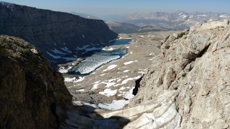
Looking back south from Forester pass over the top of the snow chute I had just crossed.

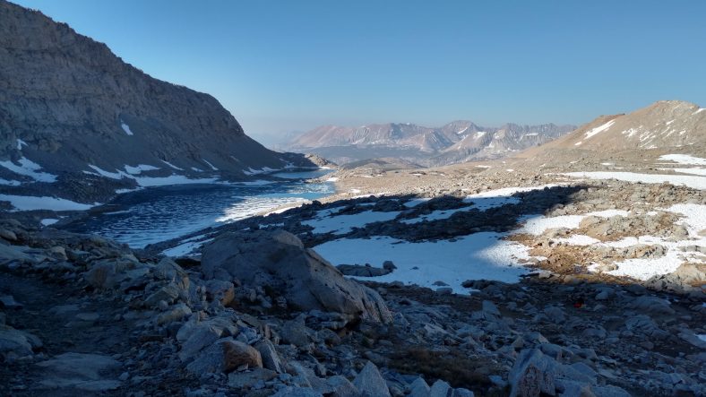
Looking north from Forester pass across the valley I am about to hike through.

Let me tell you, the view was outstanding in all directions.  The other side was Kings Canyon National Park, which is exactly what it sounds like.  It’s a huge canyon with huge mountains on either side.  And we were about to hike right through the middle of it.  There were quite a few people at the top, and being a small gap, it was a bit crowded.

I rested a bit, took in the view, had a snack, and then had a choice to make.  There were switchbacks going down the back side, or a huge snow field you could slide down if you so desired.  Yes, I desired.  I looked for an existing path that looked like it did not have too many rocks, sat on my butt, then slid down the mountain about 100 yds.  It was a blast.   I never felt out of control, I could slow down when a rock came up, and I could stay on track pretty easily.  But boy was it cold.  My pants were soaking wet and full of snow.

After the quick glissade down, there were chunks of snow in every orifice of me and the pack.  It took half an hour for my pants to dry, but it was worth it.

The fastest way down is the glissade on your butt. I took the route on the left.

The rest of the hike down the canyon was a bit uneventful.  There were snow banks and streams all over the place.  The very center of the canyon was heavily treed.  I stopped and made lunch early at 11:00 and took a quick break to reload on some water.  I made a big lunch because I had another pass, Glen pass, to hit in the afternoon.

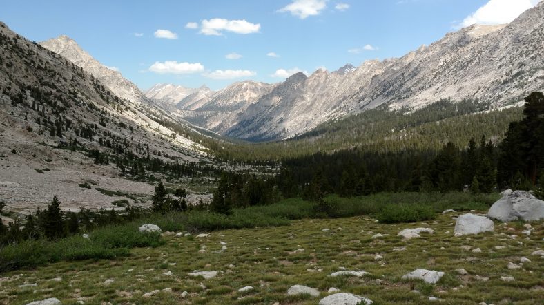
The canyon eventually turned to grass and trees where I found a good place to stop and have lunch.

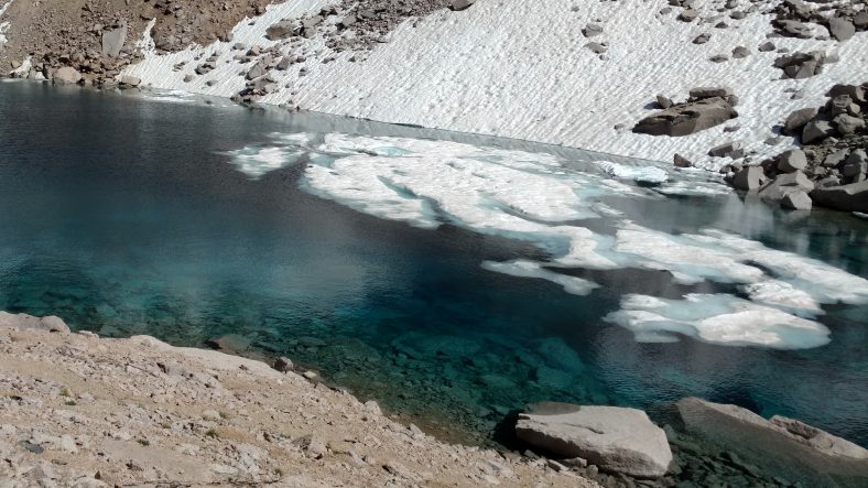
This is why the streams are so cold. Most of the ponds still have snowbergs floating in them.

After going along the canyon for about five miles, it was time to get out of the canyon and hit the next one.  The climb up was steep and would total about 3000 ft all the way to the pass.  In the middle it leveled a little, but once it got above the trees again, it turned to steep switchbacks.

I’m not sure if it was the time of day or the terrain, but Glen pass seemed way more difficult than Forester pass.  It seemed longer and steeper.  I had to rest a few times on the way up.  When I was about 700 ft from the final elevation of the pass, I started to feel a little nausea and a headache that had been brewing since about half way down the canyon began to bug me.  I don’t think it was altitude sickness, I think it was MSG again. I ate what was intended to be four servings of soup, and it felt just like the headache I got after the crappy tortilla chips a few weeks ago.  In fact, I still have it now.

Glen Pass isn’t as well known as Forester Pass, but it’s still a phenomenal place to visit.

I finally made it to the top at 4:45 PM.  The view on this pass was not as grand as Forester, but they made up for it by taking us along the knife edge of the ridge line before letting us descend.  There were not too many snow banks on the way up, but the way down had huge drifts on steep banks.  I decided to put the spikes on before descending, and that was a smart move.

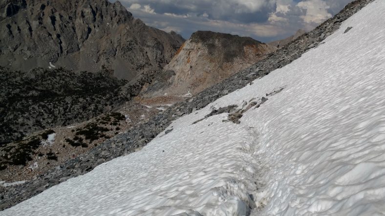
This deep trench in a steep snowfield is easy to cross since there’s no danger if you slip.

The main bank was not scary, it was nearly three feet deep, so you wouldn’t go far if you did slip.  But some of the ones further down were so steep that everyone was basically just scrambling along the side of the mountain to avoid the snow.  The scrambling looked worse than the snow, so I took to the snow.  No one had gone the official route yet, so I got to blaze the snow trail across it.  It was a blast.  It was not hard at all.  Just set your poles (with snow baskets on otherwise they sink straight down to the handles) then jam one foot like a saw into the snow until it holds firm.  Reset the poles and repeat with the other foot.  I could see the trail underneath because of rocks poking up through the snow.  I made sure to keep the snowline uphill from the trail line.  I had no problems with postholing  (where your foot goes way too deep) but could tell towards the end that there was not solid snow underneath so I did not jam my feet into the snow so aggressively.

One of the people I passed on the way down was a girl wearing sandals.  Yes, sandals. Who in their right mind wears sandals on a remote hiking trip where you have to cross snow fields at 11,000 to 13,000 ft?

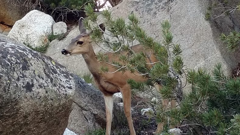
The wildlife here is pretty tame since hunting is not allowed.

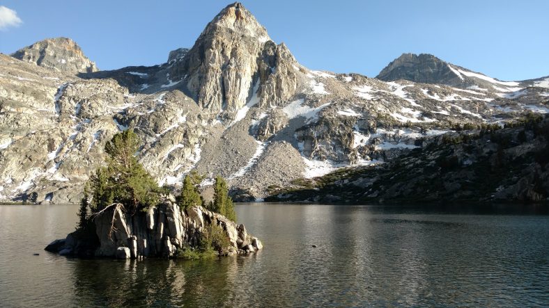
An awesome lake in this canyon looks like a good place to camp.

Between all the slushy snow and multiple streams we had to cross, my feet were soaked.  I hiked perhaps another five miles down the canyon past several large lakes to a campsite right by one of the lakes.  It is infested with mosquitoes as expected, but the tent and headnet work well.  But one area the headnet does not work well is while eating.  After cooking, I basically had to walk around the campsite while eating just to keep them out of my face.  Stop for three seconds and you are swarmed.  Life in the deep woods.

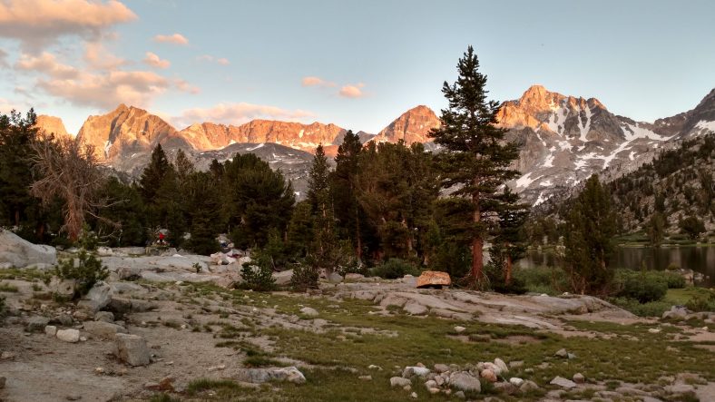
Sunset at the campsite as I get attacked by mosquitoes.

PCT mm 774.7 – About to hit the big time

I snapped a quick pic as this couple went to the shoreline to check out the view.

I slept in a little since I knew I had Forester pass coming up at the end of the day and there would be very little chance I could tackle it today.  I was off at 6:15 and the trail was pretty much the same as yesterday.  A little climb,  little level, a little down.

Mt Whitney is the highest point in the contiguous 48 states, but I did not have enough spare food to make the 8 mile side trip.

I was dragging early in the morning, so I made some coffee and that helped quite a bit.  I stopped by a stream at 11 to have first lunch and break for an hour.  Shortly after the climb up from the stream I got tired and lazy.  Not sure if I need more sleep, more food, or just some rest.  I could have rolled out the mat and taken a nap, but it was just a perfect day weather wise.  The temperature must have been about 70 and a gentle breeze blowing steadily.  Perhaps I was just sleepy from eating.

There are lush meadows, good trees, and outstanding views around Mt Whitney.

Around 3 PM it started to cloud up.  I thought I better stop and cook second lunch before the rains came because cooking in the rain sucks.  My timing was good because about thirty minutes after starting up again, it started to rain.  Wait, no, that’s not rain, it’s sleet.  Big mushy ice blobs splattering all over the ground and rocks.  After five minutes it turned to hail.  It continued to hail off and on over the next hour.  It made the hike interesting, but it was very loud under the umbrella.  I kept leapfrogging three other hikers as they sought refuge under large trees.

This is just a small patch of snow, but it’s obvious that more is coming soon.

The view during the latter stages of the hail was breathtaking.  We came to a high Alpine meadow that was almost tundra like.  There were snow drifts here and there and a lake right at the top.  The distant range still had lots of snow cover and was illuminated by the sun.  I snapped a picture as a couple I was hiking with went down to the lake.  I spent my idle time playing in the snow.

The first “Sound of Music” moment came shortly after the hail stopped.

I wouldn’t trade being here for anything in the world.

As I neared the last camp before Forester pass, there was another stream to cross.  This was probably the fourth one of the day.  All of the others I was able to rock hop across them and only get my toes wet.  This one, however, was a wader.  The rocks to hop across were a foot under water and the base of the river was over two feet deep.  Since I was less than five miles from Forester pass, I decided to take my shoes off to keep them dry for tomorrow.  I waded across and the water was so cold, it was extremely painful on my feet.  This is definitely a snow melt fed stream.  I suspect from Forester pass itself.

I camped early,  just on the other side of the river so I could wash some socks and do a little housekeeping.  There are no more tent sites between here and the pass itself other than a flat spot by some lakes that are at about 12,200 ft and very exposed to the weather.  All the terrain from here to there is steep, and finding a campsite is unlikely.  I don’t want to get too close, either, because the snow could ice over during the night.  If I leave around six, I should get to the pass around nine, so that should be good timing.  The North side has far more snow, so descending at ten should be about perfect.  My campsite is at about 11,000 ft and Forester pass is 13,200, so 2,200 ft of climb in the morning is not too bad.  I should get some coffee ready now.

PCT mm 756.3 – In bear country now


The meadows are giving way to the higher mountains of the Sierra Nevada.

Today I officially entered Sequoia and Kings Canyon national park, so the bears are for real, and so are the rangers.  All overnight hikers are required to carry a bear canister for food storage in these national parks and Yosemite.  Five miles before I even got to the border of the park, a ranger was there on the trail to check my permit and bear canister.  I passed with flying colors.

The morning started out like they all do, wake up at five and hiking by 5:45.  I had some uphill to contend with, but the mosquito’s were not as bad as they were the night before.  I passed several hikers still in their tents until nearly 8 am. Don’t they know they are missing the best part of the day?

Looking east towards Independence, CA. Apparently AT&T is there, but not Verizon.

The trail skirted a high point that had a view of a valley to the east.  The AT&T folks had signal, but not Verizon.  One of the rare service inversions. I tried several times from several vantage points and actually did get a signal a few times, but never got data or could send out texts or make a call.

Later in the day, we passed a junction that led East to Independence, CA that several folks were stopping at to resupply.  I tried to get a signal there, too, with no luck.  We are so deep into the Sierra that there are just no towns within eyesight.

There were several water sources that I passed today, so I think I never carried more than three liters and typically just two.  Sometimes when you come to water, there is a small side trail that is easy to miss.  In these cases, people make signs in the trail with stones or sticks.  I typically see something like this nearly every day.  It does help keep you from missing something like water that might be critical at the moment.

Some kind soul has marked the way to water,

The real excitement of the day was a rescue helicopter that flew overhead in the afternoon.  He came from behind me and flew almost directly overhead.  just after he passed me, he started playing siren noises like a cop car.  Can’t say that I’ve ever heard that before.  I could hear them speaking on a PA system to people on the ground, but could not make out what he was saying.  About twenty minutes later, I heard a boom very close to me in the woods to my right where a meadow was that had water.  In fact the picture is from that intersection.  It took me a few seconds to figure it out, but the boom was the helicopter igniting it’s engine so it could take off.  I watched it thru the woods.  It lifted very slowly then took off in the direction it had come.

A few minutes later, some hikers passed me and we got to talking about the helicopter.  Apparently a couple who were hiking the PCT had the wife twist her knee a few days ago and they kept hiking until the swelling got so bad, that they activated their Spot device to be extracted.  They were only two miles from the intersection that would have taken them to the trailhead and into town, so they must have been in a bad way.  They also mentioned that the altitude was so high, that they could only take the wife and even had to unload some equipment from the helicopter into the field.  The husband ended up having to take the side trail into town.  Poor guy.

Later in the afternoon the wonderful clouds that shaded us all afternoon finally turned to rain clouds and let a light rain sprinkle on us for about an hour.  I could see lightning way off in the distance but none struck anywhere near us.  It was cool but not cold.  My umbrella kept me dry, but my shoes got a little damp.

Rain clouds are approaching

I wanted to hike a little later than yesterday, but still camp with daylight left, so I found a decent spot to stop at 7:30.  I pitched the tent quickly so that I could get started on dinner.  I had not eaten enough during the day and I was hungrier than usual.  I found a good rock to cook at that was 100 ft away from the tent and proceeded to cook mashed potatoes that were more than the normal size I cook.  And as luck would have it, I boiled over the pot and got milky water all over the stove and ground.  The first time I have a cooking spill would have to be my first night in bear country.  At least it’s pretty far from the tent.

The pines are a welcome sight, but California just simply does not have undergrowth the way the east coast does.

I am camped at 11,000 ft and I’m only ten miles from the junction to the Mt Whitney trail.  The side trail to summit is 8.6 miles, so to try to summit would be a 27 mile day, which doesn’t sound doable.  I’m not a peak bagger, so missing Mt Whitney is not that big of a deal, even though it is the highest peak in the continental 48 and over 14,000 ft high.  I am camped in its shadow right now and can see it well.  Perhaps I’ll hike the John Muir trail some day, which ends at the peak of Mt Whitney.

PCT mm 731.0 – Into the Sierra at last

image

Today was a day unlike any other day so far on the trip.  It started the same.  Wake up at 5 and start hiking at 5:45.  But today I’m not supposed to see any desert.  And at no point during the day was I hot.  Sweaty, yes.  But hot, no.

About thirty minutes into the morning, I come across a woman and two young boys about ten years old.  It is very odd to see weekenders out hiking before 9 am.  I knew something was up.  Apparently one of the boys was having altitude sickness and they had run out of water and were heading back to town.  I barely had enough for myself since I had twelve miles to water and had just camped dry, but I gave them a liter.  They were only about three miles from the Kern river, so they should be fine.  The woman started crying as I gave them the water.

After talking with other hikers later in the morning, apparently they had been out of water last night, too.

Trees are the ideal hiking location when the weather is still hot.

The morning was mostly climbing, but it seemed like as we got higher, we just kept coming out into meadow after meadow.  I don’t know how many we hit today, but it had to be at least six.  I am camped right now in a place called Death Canyon Meadow.  Nice name.  It’s a nice site, just a bit heavy on the mosquito’s.  Maybe that’s where the death reference comes into play.

An endless supply of meadows all day long.

About 10:00 I came upon the main water source, another branch if the Kern river that had a bridge over it and a very large Beach.  When I got there, about eight hikers were already there.  By the time I left 45 minutes later, there were eight new hikers there.  The vortex of Kennedy Meadows has concentrated the hikers.  It was a nice stop for first lunch.

Hikers taking a lunch break along the Kern river.  Notice the abundance of birds in the air by the bridge.

More climbing was in store, but it was not steep.  I had loaded up with three liters of water, so I was a little on the heavy side.  We still have ten to fifteen miles between water sources for the next day or two before it becomes a stream fest.  About half way up the climb, dark clouds started to roll in all around us.  It looked as if we got over the pass we were headed to, we might be able to skirt the rain.  But each time the trail moved away from the clouds, the clouds followed us anyway.  Eventually it did start to rain, so I put my poles up and got the umbrella out.  It kept me dry and only my pants legs got any wetness to speak of on them.  It rained on and off for about two hours.  In the forest, it made the pine needles come to life.  In the meadows, it made the sage come to life.  Rain always brings out new smells.

Rain was very welcome this day, too. Two straight days with rain!

I was planning on hiking until close to seven, but as I was leaving Death Canyon Meadow, I remembered I still needed to repair the seam on my pack.  So I decided to stop early (about six) and do the repair before making dinner.  The mosquito’s were relentless and it was a little harder seeing with a head net on.  I finished the repair in about an hour, and while its not pretty, it should hold just fine.  It would have been nice to get access to a sewing machine in Kennedy Meadows, but my hand sewing will have to do.  I hope the cotton thread holds under the strain.

PCT mm 707.9 – Escape the Kennedy vortex

image

Leaving Kennedy Meadows in the afternoon during a gentle rain shower.


I left Kennedy Meadows today as planned, but slightly later than I expected because it started raining.  Yes, raining.  And I also ate too much ice cream.  🙂

It was a nice casual morning.  I slept in as late as I could tolerate, which was 7 am.  I gathered some of my paperwork and went up to the deck to use some of the tables.  Achilles was sleeping up there.  It was then that I noticed that the water report doesn’t even report on the Sierra section.  I guess the water is so good here, they don’t bother to collect the data.  That’s good to know, I guess.  I went ahead and perused the portion that they do report (up to Cottonwood pass) then cruised some of the register entries in the Guthooks app.  For the most part, it looks like I can rely on the Guthooks reporting of next reliable water and not bother with the water report until I get out of the Sierras.  I went ahead and scribbled notes for the next 80 miles since there are a few 10 to 15 mile carries in there.

The store down the road that has wifi and serves breakfast was closed on Mondays, so no shuttle to breakfast, and no hope for wifi.  So who knows, it could be two weeks before you read this if you are a regular follower of the blog and you probably already think I burned to death.  Well, no such luck.  I’m alive and well, just out of touch with modern society.  There was a pay phone at the general store, so at least I was able to call Karen and let her know all is well and not to freak if it takes up to two weeks for me to get a signal again.  I’m really glad I have the solar charger now.

Since there was no breakfast on Mondays, one of the local couples actually opened up the grill and had either egg or pancake breakfasts available.  It was pretty decent.  Most of the morning I just vegged out and chatted with other hikers.  Several more came in during the day and many also left.  There were probably 20 at any given time.  One of the locals said that a week ago, there were 120 there.  That’s a lot of ice cream and beer.

One of the hikers I chatted with was the person that I had noticed in the photo albums from The Grind in Wrightwood several weeks back.  He was the guy with the red vest and dreadlocks.  He was easy to spot because he was wearing a red vest and had dreadlocks.  I mentioned to him that I recognized him and noticed one year he was hiking with a girl and one year he was not.  Apparently they split up.  It seemed as if he had been there for quite a while and he looked to be in no hurry to leave, so I’m not so sure he was hiking this year.  I suspect he is one of the semi-permanent semi-hikers that take up seasonal residence on the trail.  A true vagabond.

I had one of their Italian sausages for lunch and it was actually quite good.  Much better than their hamburgers.  Since I wanted to leave at five, I cooked the rest of my hot dogs and spaghetti at about three, then went back to take a quick nap and finish packing up.  I also tried on the microspikes to make sure they fit and they fit perfectly.  I was able to get the bear canister in the pack no problem, but I noticed one of the seams that had been weakening has now split.  Rut roh.  I bought a sewing kit at the store but it’s intended for clothes not gear, so I found a roll of gorilla tape that I will use as grosgrain reinforcing and sew the seam with dental floss.  If I am able to do a good job, it should last quite a while, but if not, it might mean having to get a new pack.  That will suck.

I packed up and drug everything up to the deck to have one last Gatorade and ice cream.  I’m carrying seven days of food in the bear canister and one day outside the bear canister, so I wanted to be sure I had enough to eat before leaving so I did not have to eat from the extra day tonight.  I want to see if I can make 200 miles in eight days so I don’t have to get off at one of the crazy resupply points.

Well, it turns out you should not eat a pint of Ben and Jerry’s and a quart of Gatorade two hours after eating five hot dogs and a pot of spaghetti.  I had to sit a bit and let it settle.  And as I was chilling, it started to rain.  Not the ten drops like in Mount Laguna, but real actual rain.  It was not heavy.  No one bothered to try to get out of it, as it actually felt good.  It cooled the place off quite well, too.

Well, after 5:30, it was finally time to go.  I said my goodbyes then headed back to the trail in the rain.  It probably rained a total of an hour and wet the soil about 1/8th of an inch.  That’s not much, but I bet the plants loved it.  I loved it, too.  I didn’t bother with rain gear or anything, I just walked.  And five minutes after it stopped, I was dry.

The beginning of the National Park/Forest hike.

The trail out was sandy, but nicer than I expected.  We were back in the trees within two miles.  The next twenty miles or so will be a steady climb to higher elevations.  Kennedy was at about 6000 and I’m already at about 7000 and only six miles from town.  Tomorrow should be a fun day.