Month: July 2016

PCT mm 948.4 – Tuolumne Meadows

image

The sun sets behind the mountains as I make my way to Sierra Camp from Tuolumne Meadows.

I survived big winds last night, freezing cold in the morning, a huge snowfield, a ranger incident, miles and miles of meadow trail, a general store/post office in a tent, and a group campsite.

I camped atop Island pass last night and selected a spot behind some trees that I thought would shelter me from the wind.  I was wrong.  The wind was gusting so bad that it was deflecting the tent poles about a full foot.  I had the vestibule opening downwind, but the wind was so strong it seemed to want to turn the tent inside out.  It was also quite cold.  I did not get much sleep.  I met another hiker from Belgium in the morning who had the same experience but was so afraid his tent would collapse that he took his tent down and just wrapped himself in his fly.  He said he got about twenty minutes of sleep.  I probably got two or three hours.

Despite all the ruckus all night, I got up at 5 to try to get to Tuolomne Meadows by 3 PM.  But as I am gathering things up, I noticed one of my stuff sacks is missing and it’s former contents are scattered on the ground.  Great.  It’s too dark to look for a navy blue stuff sack, so I keep to the morning routine and wait until it’s bright enough to go looking.  As luck would have it, I finally found it stuck between some rocks about 150 yds away and almost 100 ft down.  Ten minutes later I have the stuff sack and finish packing.  I don’t get out until 6:15, which is still a respectable time given the festivities of the morning.

Have I mentioned that snow means good, reliable water? Cold water, too.

It’s only about an hour to the bottom of the canyon then begins the next climb to the next pass.  It’s cold enough that I have to wear my gloves but not my jacket.  By the time I got to Donahue pass, it’s pretty cold and I have to put on my rain jacket.  On the backside of the pass is either a rocky twisty trail, or one really long snowfield all the way down.  It’s early and the snow is still hard, so I opt for the snowfield.  It’s so long, I have to take several breaks down it, but it’s pretty good travelling.  There are boot prints I can settle into without slipping most of the way but some sections are a little steep and slippery so I opt to travel on the fresh sun cups on those and the snow is just sit enough to crunch into them a few inches but not slip.  The trail is much tamer at the bottom of the snow, so it’s quick travelling the rest of the way down the canyon.

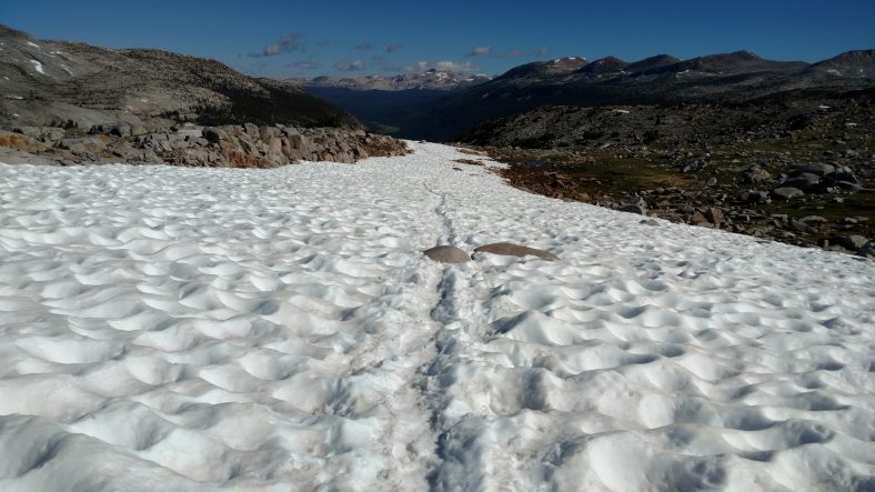
This snowfield was so large, I had to stop several times just to rest.

Travelling on the snow ended up being easier than travelling on the rocks.

Half way down to the meadow level I meet a ranger.  Only the third of the trip so far.  She asks for permit and bear canister and says my permit is not valid.  I have not signed it yet.  That’s an easy fix.  She asks if I am heading to the Meadows for the night and I tell her I plan to just buzz by and keep going and she informs me the next six miles after the meadow are no camping, so I’ll have to be sure to go at least six miles past it to the Sierra camp or further.  Good to know.  I should still have enough time.

Tuolumne Meadows is aptly named. This is not Tuolumne proper, but I’m not far away.

A Large deer hangs out drinking water and chomping meadow grass.

The rivers are slow moving here in the meadow, but they are still moving large volumes of snow melt.

Once down to the meadow level, the last eight miles to the store are easy level hiking for the most part.  I stop for lunch on a big rock in the meadow and marvel at how much I love salami and cheese.  I should eat this more often.  I wrap it in a tortilla and use a packet of Mayo and it is heavenly.  Mayo makes the sandwich.

I don’t get to the store until 3:30 or so, but the store and grill are both open.  I hit the store first for some fruit and more cheese and pepperoni and a few more items to extend my food a day.  Then I head straight to the grill, but they are out of salad, so I settle for just a double cheeseburger.  It’s a frozen patty affair, but it has lettuce and tomato so it serves as my salad.  This post office/store/grill is actually built inside a giant tent.  Very odd.  An ice cream sandwich and Pepsi later, a little small talk with other hikers, a little packing, and I’m finally ready to leave at 5:30.

A large waterfall north of the Meadows campground on the way to Sierra Camp.

The hiking out of the Meadows starts very easy on a ten foot wide nature trail, then gets a little rocky, but nothing too bad.  We are following the Tuolumne river and eventually hit a fifty foot waterfall.  The Sierra camp is not too far after that, so I turn off to go to the camp.  It’s only a tenth off the PCT and when I see it I’m a little overwhelmed.  It’s a giant complex with a store and about twenty tent cabins.  It’s not what I was expecting.  I ask one of the patrons about it and he says there is a campground in the back.  That’s more my speed.

I head back to the campground and there are at least 25 tents all around.  They have running water and a pit toilet and I do finally manage to find a good spot, so I set up quickly and eat a nutritious dinner of potato chips, carnation instant breakfast, and skittles.  Eating at the Meadows store so late is still keeping me fueled but I want to be sure to have plenty of raw materials for my body so it can rebuild while I sleep.

The Sierra Camp has rental tents and a group hall. I camped in the back.

They have bear storage lockers so I put everything that even remotely has a smell in it except for my bear canister.  These big campsites are almost always frequented by bears, so I don’t want to take any chances.  Let’s hope for uninterrupted sleep tonight.

PCT mm 924.7 – Escape from Mammoth

image

Another impressive view of a snow laden mountain providing fresh drinking water.

Hurray!  I managed to leave Mammoth Lakes.  I enjoyed being there and needed the rest, but it feels so good to be back on the trail where I belong.  I also managed to knock out enough miles to be able to hit Tuolumne Meadows in the afternoon instead of evening.

I slept in because the buses don’t start until 9 am and the bed was quite comfy.  The mattress were soft, and they were fitted with nice sheets, a blanket, and a comforter.  We left the windows open and it felt quite nice while sleeping.  I was still the first one up at 7:30 and went up to the kitchen to eat my breakfast.  One of the managers had also gotten up and made some fresh coffee.  I heated up the potato wedges from dinner and ate them first.  Then toasted the bagel and ate it with butter.  Bagels are so much better when toasted.  Then the orange and banana, and finally the cinnamon bun.  As big of a breakfast as that was, I could have eaten more.  The manager was already starting to make pizza dough as I was finishing.

I packed up pretty quickly and was out of the hostel at 8:40.  The trolly did not start until 9 am but so did the bike bus, and that was the critical one to get to the adventure center.  The walk to the village took 15 minutes and the bus was already loading bikers by the time I got there.  They load bikers until the rack is full, then they hold the rest of the bikers for the next bus and then load the hikers who have to stand.  There were at least twenty hikers there so I was nervous there would not be enough standing space for all the hikers, but there was.  The ride took about fifteen minutes, and I immediately got in line for the Reds Meadow bus.  I was about eighth in line so I was happy I would get a seat this time.  Nearly all the other hikers had to go buy tickets which meant they were not PCT hikers.

The ride back out was much better this time, being able to sit for the long ride.  It also did not take as long because we did not have to stop at all the stops, either.  I think it was a bit after 10:00 when we finally got to Reds.  I went in to the store to buy a Starbucks frappachino and some coffee candy to have with my kale, chicken, and cranberry salad that I brought from Vons grocery.  There were some other PCT hikers there but I had only met one of them previously at VVR.  They were all envious of my salad.  I was able to find some coffees, drink mixes, and Ritz crackers in the hiker box.  I stashed them in my food bag and was finally off at about 11 am.  That’s about when I had figured I’d finally get back on the trail, so I guess everything was going well.

Heavily forested trail leaving Reds Meadow.

The trail out was pretty mellow with an easy grade.  A mile and a half up the trail was the Devil’s Postpile which is an odd formation of volcanic rock in tall hexagonal shafts that look like pencils and a pile of broken pencils below them.  I was able to see it well enough from the PCT and did not feel the need to take the side trail to hike above them.

The Devils Postpile consists of very odd hexagonal shaped columns of rock.

Most of the day was pretty mellow.  The mid afternoon the trail climbed up switchbacks on a mountain with sage on it and I was afraid we were going back into the desert.  It was just that one hill, and the temperature was cool all day anyway.  I was making good time to be able to cross the next pass before dark, so I pushed on.  By late afternoon I had gotten quite hungry since I ate my lunch early at Reds.  I didn’t fix an official lunch or dinner but I had an extra tuna packet of tuna salad that I wanted to try on a tortilla.  It was pretty good.  I might make that a staple at some point.  As the day went on, the trail got rockier and I slowed down a little.  Looking at where I was, I would get to the pass right at sunset.  I would probably have to hike a few miles past the pass to find a camping spot, so I was prepared to walk into the dark.

The trail winding higher in elevation.

I had gone light on water, so as I approached the pass, I had planned on picking up water at 1000 island lake, which is the one in the first picture.  The trail actually did not go too close to the lake and immediately started climbing again, so I did not get water from there.  It was also quite windy so I did not want to go down to the lake to camp.

Plenty of snow means plenty of water to be had.

I stopped at a small lake just before the pass to filter two liters so I could have one to camp and one to hike in the morning.  The water delay means I would miss sunset at the pass and I saw it from the lake instead.  What I did not realize was that while filtering water, I was essentially only two tenths of a mile from the pass.  This one had no climb to speak of.  And as luck would have it, I found a nice camping spot just a tenth beyond the pass that had decent protection from the wind, so I stopped there.  I had plenty of light to make camp, cook, and eat, but then the light faded as I was cleaning up.

I am just over 17 miles from Tuolumne Meadows now, so I should be able to make the store by 2 or 3 PM if I get up at 5 in the morning.  I think it’s about 75 miles to the next resupply from there, and I should be able to do that in three or four days.  I am carrying four days of food and hardly cracked into the first day yet, so I may not have to buy much of anything there at all.  That would be nice.  I’ll double check my notes when I get there tomorrow since I can’t afford to make any resupply mistakes out in the remote woods I am in right now.  One comfort is that there are so many hikers here, that if I did run out of food it should be pretty easy to bum some off the week-long hikers that are all over the place.

PCT mm 906.6 again – Zero in Mammoth Lakes

image

The town center was having a Jazz festival and wine walk today.

I did end up taking a zero day today.  I did not sleep that well last night and don’t feel great and still have a bunch of errands to run today, so instead of rushing to get them done and get out of town, I’ll just stay here again tonight since this is a pretty good hostel.

I got my gear related chores done before lunch.  One of those was fixing my regular prescription glasses.  I brought my old pair that were pretty worn out because I thought they might get scratched up and it turns out that sometime in the last 300 miles they broke in half right across the bridge.  Another hiker had some super glue so I glued them with that and then reinforced the joint with a section from a plastic spoon.  This would be the second repair with a black plastic spoon for these glasses.  They are holding so far, but I expect they will get broken again before too long.

I ran into the village for lunch because I was craving a salad.  I had a mixed green salad with salmon on it and it was great.  I spent the rest of the afternoon running the full bus route to see the other side of town and going back to the grocery to get breakfast.  I have a bagel, orange, banana, and cinnamon roll for breakfast and a kale and chicken salad for lunch.  The shuttle from town to the adventure center does not leave until 9:00 so I don’t expect to get to Reds Meadow until at least 10:30, so I might as well have an early lunch there before I head out.

I grabbed dinner on the way back into town and then headed to the jazz festival before coming back to the hostel.  They were also having a wine walk with about a dozen wineries.  I didn’t stay long at the jazz festival because the sun had gone down and it got downright chilly there and I did not had a jacket.

The band playing at the Jazz Festival in Mammoth Lakes, CA

Nearly everything is packed and ready to go.  I want to catch that first bus to the adventure center so I’ll head out from the hostel about 8:30 and walk to the village.  It’s less tan a mile and all downhill.  I want to be able to make as many miles from Reds as possible so I can get to Tuolumne Meadows quickly.

PCT mm 906.6 – In civilization again

I don’t think the trees like growing on mountains this steep.

Where I camped last night was pretty high and right near a snow bank.  As I was cooking dinner and going to bed, it was quite cold.  I was afraid I was going to have a very cold night but I think that it was just that at that time of day the wind was blowing towards me from the snow, and then several hours after sundown it warmed up quite a bit.  Around midnight or so it was quite comfy.

I set out at 6 am and I was in good spirits.  I had just vapors of food and carried no water for the first five miles.  My pack was light as a feather and it was a nice morning and mostly downhill.  I crossed paths with many hikers coming uphill who were not in such great spirits.  Their loss.

I passed the 900 mile point today.

The forest leading into Red’s Meadow burned several years ago and is a mere shadow of it’s former glory.

I reached Reds Meadow about 11:30 and immediately headed for the store for a plum and an orange soda. I rested a bit then got on the next bus heading into town.  The roads in Inyo National Park are so small and narrow they encourage everyone to ride the bus in the park.  It works for me.  Once at the main ski lodge, you have to take a different bus to the main hub in town.  Then you can get on a third bus to get all around town for free.  Works well for hikers.  I headed straight for the hostel to shower and get all my clothes ready for the laundromat.  It took me a while to get the hang of the buses, but I eventually got there and did food shopping at the grocery while waiting on the laundry.  Hop on another bus and I’m back at the hostel.

No shortage of directions at Red’s Meadow.

The hostel setup is nice.  They have fixings to make your own pizzas and watch movies all night.  It was nice and relaxing for a change.  I still have not decided if I am leaving tomorrow or if I will stay here for a zero tomorrow.

PCT mm 895.4 – Full belly

image

Have I mentioned that there is a large lake in every meadow in the Sierra?


The crowd around the fire last night stayed up til 11 so I listened to music for an hour to drown them out and then in the morning again when I woke up at five because the store and restaurant didn’t open until 7 am.  I got up at 6:30 and started packing and was able to get 90% packed by the time the restaurant opened.  I had breakfast with another hiker from Portland who did Oregon and Washington last year and is just doing California this year.  The breakfast burrito at VVR is top notch.  At the time I was thinking that I was going to order two breakfasts but just one burrito did the trick.

I was able to close out my tab and buy a few last minute food items and finish packing before the 8 am ferry was ready to roll.  We set out across the lake at 8:30 and I was back on the PCT right at 9.  And of course the trail would begin climbing immediately.

Most of the day was uneventful.  Only one pass for the day, very little snow, the usual number of streams.  The burrito held me well all morning so I did not break for lunch until 2.  I loaded up on water and made some lemonade.  The only excitement of the day was while crossing a stream on a log that was wet, my foot slipped in the water and then the other foot of course.  I cracked one of my poles while trying to keep from face planting in the stream.  It’s still usable but will no longer collapse.  I don’t know if the warranty will cover this kind of damage, but I’ll find out at the next REI opportunity.  I know Leki covers damage like this.

The terrain is a bit rocky and steep as we head towards Red Meadows so finding a campsite is not as easy as other places.  I stopped a half mile before my intended destination because I found a nice soft flat spot without too many mosquitoes.  A bird in the hand, you know.

I am now 11 miles away from Red Meadows, where they have a small store and restaurant and have a bus that goes to Mammoth Lakes every 20 minutes.  This is where I hope to finally get cell service.  I should be able to get to town well before lunch if I leave early in the morning.  There are two hostels and laundry, but I’m not sure about the restaurant situation.  They have a full size grocery store and a movie theater.  Now that I’ve slowed down a little bit with the VVR side trip, I don’t feel the need to take a full zero in Mammoth, but we’ll see.  After all, they have a brewery, too.

PCT mm 878.7 – Vermilion Valley Resort


Waiting on the shoreline for the ferry to VVR, but the real landing is on the other side of these rocks and I almost missed the last ferry of the day.

I get to actually see civilization today.  Even though I have enough food to make it to Reds Meadow and Mammoth Lakes tomorrow, I’m craving real food so I’m taking a side trip to VVR.

I tried the fleece under the back trick last night and it worked out splendidly.  I slept well and could even sleep on my side with the fleece still underneath me.  I woke up at 5am and decided to listen to music instead of trying to sleep in.  Pink Floyd Animals.  Nice and mellow for my mountain lake campsite.  When I did get up thirty minutes later, I was not as stiff while moving around.  I got going at 6:30 and had no back pain.  Voila.  I did have a small twinge of pain around 10:30 while putting shoes on after a river crossing, but it went away in ten minutes or so.

Every valley in the Sierra has a big lake in it…. and mosquitoes.

About those river crossings… There’s usually twenty to thirty small streams to cross every day, and rarely a big one you need to actually wade.  Well today there were three crossings that required wading and I didn’t want to have wet feet all day so I took my shoes and socks off for all three of them.  They were all very fast flowing and about mid thigh deep.  Even with poles it was a chore keeping balance against the current.  And the water was ice cold to the point of causing physical pain after about ten seconds, but the crossings took thirty plus seconds to complete.  About ten seconds after you get out the feeling comes back and you feel refreshed for about twenty minutes afterwards.

Small snow fields like this add an interesting twist to the day.

There were two climbs of the day that were not too bad, but what I was really looking forward to was getting to Edison lake where I could catch the ferry to VVR.  The picture is from the ferry landing site.  They run two scheduled ferries at 9:45 and 4:45.  The ferry site is 1.5 miles off trail and quite a pleasant hike.  I got there at 3:30 and found that the ferry had just been there just a few minutes before.  I could hear the boat motoring away.  Darn, could have gotten there earlier.  No worries, find a nice rock and listen to tunes.  AC/DC High Voltage this time.

About 4:45 I decided to look around.  To my horror, the ferry was a quarter mile away and loading passengers.  I hauled ass and managed to get there just in time to grab the last seat on the last ferry.  That would not have been good to miss the boat, as the trail there is five miles of ups and downs.  If that had happened, I probably would have bailed out and just headed on to Mammoth Lakes.

Riding in the ferry to VVR for a hamburger and beer.

But I did make the boat, and I did get to VVR and I did get a hamburger with fried jalapeños on it.  Pure gastronomic bliss.  A soda and ice cream coated the belly as well.  This place is still out in the middle of nowhere and has no cell service or wifi but they do have a computer you can use for 30 minutes for $5, so I was able to send out a quick email to let the family know I am still alive and make a quick blog post telling the same.

Mourning the loss of this giant tree. Actually, just avoiding mosquitoes.

I talked to quite a few people, too.  A guy had been hiking with his son here earlier in the week and brought his entire family back out just to talk to PCT hikers.  Two of his kids were interested in hiking the PCT so they were out doing reconnaissance.  The PCT hikers that are here are a new batch for me, so it was nice to meet some new faces.  I have not seen any of the hikers from Kennedy Meadows here.

The store opens at 7 am tomorrow, so I will grab a quick breakfast and try to catch the early shuttle at 8 am so I can get a good chunk of the mileage to Mammoth Lakes out of the way tomorrow and have an easy day in the following day.  I was able to score four packets of tuna from the hiker box so I don’t think I need to buy any food from the store tomorrow.

PCT mm 864.2 – An easy day

image

A small feeder stream about a half mile before crossing Evolution creek.

My back was pretty sore when I woke up and I didn’t get much sleep because of more apnea episodes, but I think I might have that licked.   And for the first time in a while, I did not ascend a snow covered pass, or any pass, but I am close to one that I will go over tomorrow.

The last few days my back has been sore if I bend over for too long and has been stiff in the morning.  I have had back trouble for 25 years, but it usually has not bothered me while hiking until now.  I have some guesses of what it is and what it isn’t.  I don’t think it’s the extra weight of the bear canister and snow gear.  I’m carrying less water and I’ve carried more weight before.  It could be accumulated stress of hiking, but I don’t think so.  It could be that I’m sleeping on a less supportive pad.  This thing does not give much support.  I have been sleeping more on my back than side lately, so maybe I need something under my lumbar.  I am trying putting my fleece pants under my back tonight.  It could be the poles.  I have been using them all day for the last week or so.  Without poles I can shift the pack around on my back in ways I can’t do while using trekking poles.  If the sleep changes have no effect, I’ll try that next.

On to the apnea.  I camped pretty high last night – 11,200 I think was the altitude.  Shortly after going to bed I began experiencing the episodes and finally about midnight I had an idea.  I was in the tent with the vestibule zipped up.  I have a double zipper where I can unzip it from the top to make a chimney to ventilate better.  I did that and then unzipped the screen enough to stick my head out.  After fifteen minutes of that, no episodes.  Plus I noticed it had gotten cold enough by then to drive the mosquitoes away so I just unzipped the whole netting and pulled it back.  That seemed to do the trick, so I took another sleep aid and went to sleep quickly.  I put my fleece over my head so the sun would not wake me up and that seemed to do the trick.  So basically, the higher the altitude, the more I am essentially suffocating myself with the tent all zipped up because the CO2 builds up inside the tent.  Easy solution if there are no bugs.

Entering the John Muir wilderness area. There’s not much difference here between a wilderness area and the normal National Parks on the PCT – they are both equally rugged and both well marked. On the AT, they are easy to tell apart and getting lost in a wilderness area is a normal occurrence as the trails are much less well marked and its very easy to go down a false trail.

So with the lack of sleep and the hard day before, I let myself sleep in as late as I wanted.  Which turned out to be 6:30.  There was a lot of dew and even some frost, so the later start allowed me to be able to dry things out before packing up and leaving.  Even with that, I still got out at 7:30.  It was pretty rocky and with my stiff back, I was not very comfortable at all.  It was slow going and one crossing early on I had to take my shoes off and that aggravated my back all over again.  It wasn’t until close to noon until my back felt better.  That’s one of the reasons I’m experimenting with sleeping first, because hiking does eventually make it feel better.

Can you tell the difference between lake and sky? It’s hard to tell sometimes.

A gentle breeze on this lake gives away which is water.

The highlight of the day was crossing Evolution creek.  It’s supposedly the toughest crossing so much so that they have made an alternate route that crosses at the meadow where it is much wider and not as deep.  Every south bounder I saw today I asked if they took the alternate route.  Every one of them said yes and when I got to the intersection, the normal way was blocked off with logs.  That settled that.  The picture is from the evolution meadow, but that was a much smaller feeder than the main stream.  When I got there, several people were there and had just crossed.  I decided to take my shoes, socks, and pants off and safe across in my skivvies.  It was about 50 yards wide and never got over mid thigh.  But even that shallow, it had a lot of force pushing me downstream.  They should probably make the alternate be the permanent route.

After crossing, I sat in the sun to dry off and talk to another PCT hiker who crossed just after me.  He has also hiked the AT, and we talked some about that.  But what we mostly talked about was food.  I was running a little low, to the point where I will probably stop at Vermilion Valley resort tomorrow, but he was flat out of food.  He was headed to Muir Trail Ranch eight miles away to see if he could raid their hiker box.  I saw him later in the day and he was able to get some oatmeal and noodles.  So he should be set for VVR.

Camping next to water is a recurring theme in the Sierras. It’s hard to find a campsite without it.

From about three o’clock onward, our downhill turned to an uphill.  We now begin another ascent of another pass.  There were camping spots a few miles short of the pass, so that was my goal.  The first one did not look good, the second one riddled with mosquitoes, so the third one it was.  It is overlooking the last lake before the pass and has quite a few mosquitoes, but is better than the other spots.

PCT mm 842.6 – Let’s call it a snow day – Muir pass

The hut atop Muir pass is considered an emergency shelter, but it’s pretty swank.

Another long day today.  I went over Muir pass towards the end of the day and it was a long and rough five miles over the pass.  I intended to go another mile to a campsite but this spot next to the river overlooking Muir pass looks good enough to me.

I slept like a baby last night.  I don’t think I awoke once until 5 am.  I lazed in bed for another half hour before getting up and I was on the trail at 6:30.  It was a long and steep descent into the canyon with lots of large rock steps.  They’re not any more fun downhill than uphill.

Rise and shine! Early morning is the best time of day to hike.

Once near the bottom of the canyon it was a nice densely forested are with lots of streams and a meadow that was so nice I wanted to stop and camp at 10 am.  The first five miles up the other side were just as nice and there were only small sections that were steep.  No more than a quarter mile before it tamed out for a quarter mile.

Streams like this are impossible and dangerous to cross without a bridge or substantial log..

Streams like this are a piece of cake to ford.

I love hiking among the trees where their ample shade can keep the direct sun off of you.

Tree/meadow combination terrain is hard to beat – shade plus a view.

The last four miles or so to Muir pass were pretty brutal, though.  It’s not that it was steep or rocky, but that there was so much snow all over the place that it was hard to stay on trail.  I know at least one full mile of those four I was not on trail.  And then when I would find the trail, there would be no footprints in the snow.  People were making their own trails where ever they wanted to.

Hiking along this stream increases anxiety as you know eventually you will have to cross it.

Some of the snow was deep and it was thoroughly exhausting to slog through.  I put on my microspikes pretty early into the snowfields which helped with traction, but the straps trap snow and your feet get very wet very quickly.  I wasn’t worked about frostbit because it was sixty degrees, but my toes felt frozen.

Some of the tracks across the snow were quite dangerous, too.  I saw at least three ice bridges where there were tracks on top of them.  An ice bridge is when there is a thick blanket of snow, but melting snow has flowed underneath it such that there is a smaller layer of snow with an air gap below it and run ng water below that.  Some of them were small, and not that dangerous – perhaps a three or four foot fall into six inches of water with only one foot thick of snow to support you.  But one was huge and scary – four feet of snow over a rushing rapid that was at least a fifteen foot drop into four or five feet of water moving very rapidly.  I did inadvertently end up going over there be by accident.  I didn’t realize it was an ice bridge until I was already half way across.  You could not see the running water from where I started, but you could see it half way across.  I stepped very gingerly for the ten feet or so I was at risk.  It would have been about a four foot drop and I guess I had about three feet of snow supporting me.  I used my ears as well as my eyes after that.

This is a very dangerous snow bridge over a 20 foot drop where several hikers have been walking straight across the top of it. Not me.

I could see people coming down as I was going up and could tell that they were nowhere near the trail. I just kept following trail until I lost it, then check with the GPS to see which direction it was from me, then bushwhack back to the trail and repeat.

I got to the top about an hour later than I was expecting and was glad to get there.  At the top is a round stone shelter built in honor of John Muir.  Even the roof is made out of stone.  It had a fireplace but it was bricked over.  There’s not a tree for two miles of this thing so it’s probably best that it’s shut out to keep the wind out.  I expected it to be windy, but it was actually a very nice day with just a gentle breeze.

The last snow climb up to the hut at Muir pass. You can clearly see what a sun cup is in this picture.

People I had met going southbound had mentioned the climb up would be long, brutal, and snowy.  But they all said the North side was a walk in the park.  Boy were they wrong.  I had a similar experience losing the trail and not seeing footprints where they should be.

Plenty of snow on the north side of Muir pass and very indistinct trails.

It was five miles down to the nearest camping spot and I wanted to get there with enough light to do all the camp chores.  I had enough energy, but it took forever with the navigation problems and dodging water and mud.  I found a closer spot about 7:45 so I will stopped there and had just enough time to get everything done.

A nice camping spot on sand and gravel with big slab rocks to sit on and cook. This picture is posed – I cook and leave the bear canister about 80-100 yds from the tent to keep food smells away from where I sleep. But I sit on the bear canister as a stool while I cook.

I will try to sleep in tomorrow and relax a little more.  I’m not sure what’s in store yet other than the largest river crossing of the trip.  I’d like to make it a shorter day to rest up a little, but these passes more or less dictate where you can and can’t stop.  I hope I can stop in the middle of a canyon for a change instead of rushing to get out of one and into another.

PCT mm 819.4 – A very long day – Pinchot and Mather passes


I love the early morning light for hiking. Hiking is the reason I am a morning person now.

I got up on time and was out hiking by 6 am and hiked until 8:30.  I wanted to be able to tackle both Pinchot and Mather passes today to avoid making it a short day.  The passes are so high, there’s usually two or three miles on each side that are not suitable for camping.

It was either stop short, or go long.  The day went well enough that long was in the cards.

First up was Pinchot pass.  From where I had camped at Rae lakes just beyond the previous Glen pass, it was all downhill for about five miles.  At the bottom was a suspension bridge that was quite shaky and rickety and also very high above the water.  I could not look down or out at the river.  To make things worse, some of the boards were loose.  I was glad to be across.

The suspension bridge for hikers – horses have to go downstream and ford across.

Backwoods comedy.

Then the grueling climb for five miles began.  I had to climb back up 3000 ft but what made it difficult was the trail itself.  The trail had lots of oversized water bars and oversized steps that really take the juice out of you.  I had to stop about half way up to make lunch at 11 am.  I was just totally out of energy.

A typical stream crossing in the Sierra can be easier if there’s a log across it.

Lunch did pick me up a bit.  The trail was still difficult, but I had more energy to tackle it.  Like all passes, the last mile is switchbacks straight up a cliff.  I got to the top just before 2 PM, which is the latest time I could get there and still have a chance at getting to Mather pass.  There were four JMT (John Muir trail) hikers at the top and we got to talking about what each of us could expect ahead.  Since we were going in opposite directions, that was easy.  When everyone is headed north, you can’t get that kind of intel.  They told me the South side of Mather was plain switchbacks, but the North side was a landslide and full of snow.  That could make getting to camp interesting.

The JMT and PCT follow each other for about 180 miles.

The nearest camp was 2.5 miles on the other side of the pass, and 2 miles before the pass.  Those were my two options.  If I could make the peak by 7:30 I should be able to make the far camp just about fifteen minutes before dark.  Which meant I had to make the first camp by 6:30 to be able to make the peak by 7:30 and so on.

Water is everywhere in the Sierra and never hard to find.

The descent from Pinchot pass was not too difficult, and only about 2200 ft instead of 3000 ft.  There were lots of stream crossings there, and pretty much all day.  Possibly over twenty of them.  Most of them have rocks that you can hop across, some you have to hunt up or down river for a better crossing (like a tree across the stream) but two of them I had to take shoes and socks off and wade across.  It gets old after a while.

A large log makes a stream crossing easy peasy.

About half way back up the ascent to Mather pass, I took another break to eat a snack and make some coffee.  Coffee really does work.  I was energized all the way up to the pass.  I got to the first campsite about fifteen minutes after my cutoff, but felt so good I pushed on anyway.  I ended up hitting the top of the pass fifteen minutes early, so I had a light snack and some water before heading down.

A hiker soaks in the view before heading up Mather pass.

The north slope had lots of switchbacks like the South side, but not as steep.  What it also had was snow.  Lots of snow.  Tracks went everywhere.  Some people glissaded down and then went cross country to get back on trail.  I didn’t want to get wet or go cross country so I stayed on trail as best I could.  There were so many sections of trail covered in snow that it was hard to figure out which way to go.

It’s hard to get tired of the SIerras, but they sure do make you tired.

The climb down took longer than I expected because of the navigational challenges and also because the trail was full of loose rocks.  I could see the lake where the campsite was as soon as I hit the pass, but it just didn’t seem to be getting any closer.  But eventually it did arrive.  There were other campers at the site and they were already in bed, so I quickly got water, set up the tent, then cooked dinner.  I had enough light for everything but making dinner, so I did that by headlamp.  It’s been a long day, so dinner was good and let’s hope sleep comes easily.

The many passes in the Sierra give outstanding views in every direction.

PCT mm 794.3 – Forester pass and snow

image

Looking up towards Forester Pass, the highest point on the PCT at just over 13,000 ft.

What a day today was.  Two big passes to cross and lots and lots of snow.  It just keeps getting better and better.  It was just shy of a 20 mile day today, and every single one of those was earned.

Hello, Mr Sun. So glad to see you today.

I woke up at normal time and was off at 5:45.  I had about five miles to Forester pass and about 2200 ft of climbing.  I camped at 11000 ft, which I did a few nights ago as well, but for some reason last night I was having a few hours of apnea where I would feel like I was not breathing and take a big gasp of air.  It happened off and on all night.  It’s annoying when it happens because it makes you wide awake.

The approach to Forester Pass is an enchanting alpine hike.

The first half of the climb was a lot more gentle than I thought.  There was very little vegetation so the views were outstanding.  About half way up it flattens out into an alpine tundra like terrain with rivers of melting snow all over the place.  The last mile or so is switchbacks all the way up to the pass.  The little snow fleck towards the left of the picture is Forester pass.  Yes, I hiked up the side of that cliff to get up there and over the back side.  The route switchbacks up the mountain on the right, then crosses the snow field in the chute and crosses the pass from the left.

As you ascent up to the pass and look back, you can see just how much snow there really is.

The switchbacks up were not too bad.  There was very little snow to contend with until I came to one large drift and it was a little frozen over, so I backed down and put my microspikes on.  Microspikes are like flexible crampons.  They are chains and rubber and have strategically placed downward facing spikes.  They fit well over my shoes and worked flawlessly.  Two other hikers passed me while I was putting on the spikes and they did it in bare sneakers.  I wasn’t willing to take that chance since it was about 1000 ft down.  With the spikes, it was so frozen I was still a little hesitant.  Little did I know at the time, but that one snow bank was the one you see in the picture and I was basically at the top already.

Looking back south from Forester pass over the top of the snow chute I had just crossed.

Looking north from Forester pass across the valley I am about to hike through.

Let me tell you, the view was outstanding in all directions.  The other side was Kings Canyon National Park, which is exactly what it sounds like.  It’s a huge canyon with huge mountains on either side.  And we were about to hike right through the middle of it.  There were quite a few people at the top, and being a small gap, it was a bit crowded.

I rested a bit, took in the view, had a snack, and then had a choice to make.  There were switchbacks going down the back side, or a huge snow field you could slide down if you so desired.  Yes, I desired.  I looked for an existing path that looked like it did not have too many rocks, sat on my butt, then slid down the mountain about 100 yds.  It was a blast.   I never felt out of control, I could slow down when a rock came up, and I could stay on track pretty easily.  But boy was it cold.  My pants were soaking wet and full of snow.

After the quick glissade down, there were chunks of snow in every orifice of me and the pack.  It took half an hour for my pants to dry, but it was worth it.

The fastest way down is the glissade on your butt. I took the route on the left.

The rest of the hike down the canyon was a bit uneventful.  There were snow banks and streams all over the place.  The very center of the canyon was heavily treed.  I stopped and made lunch early at 11:00 and took a quick break to reload on some water.  I made a big lunch because I had another pass, Glen pass, to hit in the afternoon.

The canyon eventually turned to grass and trees where I found a good place to stop and have lunch.

This is why the streams are so cold. Most of the ponds still have snowbergs floating in them.

After going along the canyon for about five miles, it was time to get out of the canyon and hit the next one.  The climb up was steep and would total about 3000 ft all the way to the pass.  In the middle it leveled a little, but once it got above the trees again, it turned to steep switchbacks.

I’m not sure if it was the time of day or the terrain, but Glen pass seemed way more difficult than Forester pass.  It seemed longer and steeper.  I had to rest a few times on the way up.  When I was about 700 ft from the final elevation of the pass, I started to feel a little nausea and a headache that had been brewing since about half way down the canyon began to bug me.  I don’t think it was altitude sickness, I think it was MSG again. I ate what was intended to be four servings of soup, and it felt just like the headache I got after the crappy tortilla chips a few weeks ago.  In fact, I still have it now.

Glen Pass isn’t as well known as Forester Pass, but it’s still a phenomenal place to visit.

I finally made it to the top at 4:45 PM.  The view on this pass was not as grand as Forester, but they made up for it by taking us along the knife edge of the ridge line before letting us descend.  There were not too many snow banks on the way up, but the way down had huge drifts on steep banks.  I decided to put the spikes on before descending, and that was a smart move.

This deep trench in a steep snowfield is easy to cross since there’s no danger if you slip.

The main bank was not scary, it was nearly three feet deep, so you wouldn’t go far if you did slip.  But some of the ones further down were so steep that everyone was basically just scrambling along the side of the mountain to avoid the snow.  The scrambling looked worse than the snow, so I took to the snow.  No one had gone the official route yet, so I got to blaze the snow trail across it.  It was a blast.  It was not hard at all.  Just set your poles (with snow baskets on otherwise they sink straight down to the handles) then jam one foot like a saw into the snow until it holds firm.  Reset the poles and repeat with the other foot.  I could see the trail underneath because of rocks poking up through the snow.  I made sure to keep the snowline uphill from the trail line.  I had no problems with postholing  (where your foot goes way too deep) but could tell towards the end that there was not solid snow underneath so I did not jam my feet into the snow so aggressively.

One of the people I passed on the way down was a girl wearing sandals.  Yes, sandals. Who in their right mind wears sandals on a remote hiking trip where you have to cross snow fields at 11,000 to 13,000 ft?

The wildlife here is pretty tame since hunting is not allowed.

An awesome lake in this canyon looks like a good place to camp.

Between all the slushy snow and multiple streams we had to cross, my feet were soaked.  I hiked perhaps another five miles down the canyon past several large lakes to a campsite right by one of the lakes.  It is infested with mosquitoes as expected, but the tent and headnet work well.  But one area the headnet does not work well is while eating.  After cooking, I basically had to walk around the campsite while eating just to keep them out of my face.  Stop for three seconds and you are swarmed.  Life in the deep woods.

Sunset at the campsite as I get attacked by mosquitoes.